

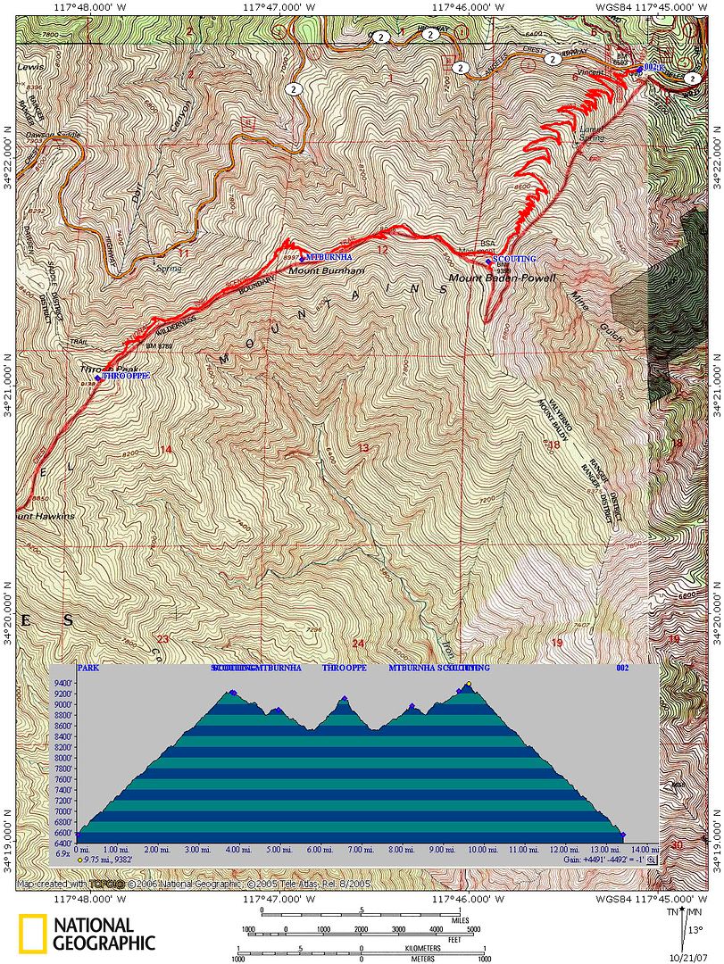
Dave G suggested a hike to Baden-Powell from Vincent Gap which swithbacks up the north side of Baden-Powell since the shade might offer some relief from the heat of this last weekend. Once we spotted Mount Burnham and Throop Peak from the summit of BP we knew we had to go on.
To keep us cool we placed snow in our hats and rolled snow in bandanas and wore them around our necks. We used snow from the remaining small patches we crossed along the PCT. It was soft and easy to cross.
Approx 15 miles and 3900 elevation gain/loss. Another great day in the mountains!
my pix are here:
http://picasaweb.google.com/ryan.norma8 ... adenPowell#
Baden-Powell, Burnham and Throop 5/17/09
-
EnFuego

- Posts: 677
- Joined: Mon Dec 15, 2008 11:14 am
Hey Norma R. Nice pics. Looks like you two had a really fun day. I heard your Shasta trip is off. Bummer. I was supposed to go back on the 21st, but that one fell apart too. I'm bummed, but have a couple other trips in mind now. I'll PM you some invites.
-
simonov

- Posts: 1102
- Joined: Tue Nov 27, 2007 5:44 pm
- Location: Reno, NV
Whoa, I would have expected more snow on the north side of Baden-Powell.
I guess winter is officially over in the San Gabriels. Now I have to negotiate snowfields on the way up San Gorgonio this weekend.
I guess winter is officially over in the San Gabriels. Now I have to negotiate snowfields on the way up San Gorgonio this weekend.
Nunc est bibendum
-
Hikin_Jim

- Posts: 4688
- Joined: Thu Sep 27, 2007 9:04 pm
Which way are you headed up?simonov wrote:Whoa, I would have expected more snow on the north side of Baden-Powell.
I guess winter is officially over in the San Gabriels. Now I have to negotiate snowfields on the way up San Gorgonio this weekend.
-
Kit Fox

- Posts: 152
- Joined: Tue Dec 25, 2007 11:33 am
It is actually closer to 13.5 miles with 4500 feet of elevation gains and losses. I did it once, and really enjoyed the solitude.norma r wrote:Dave G suggested a hike to Baden-Powell from Vincent Gap which swithbacks up the north side of Baden-Powell since the shade might offer some relief from the heat of this last weekend. Once we spotted Mount Burnham and Throop Peak from the summit of BP we knew we had to go on.
To keep us cool we placed snow in our hats and rolled snow in bandanas and wore them around our necks. We used snow from the remaining small patches we crossed along the PCT. It was soft and easy to cross.
Approx 15 miles and 3900 elevation gain/loss. Another great day in the mountains!
my pix are here:
http://picasaweb.google.com/ryan.norma8 ... adenPowell#

-
Hikin_Jim
- Posts: 4688
- Joined: Thu Sep 27, 2007 9:04 pm
-
simonov
- Posts: 1102
- Joined: Tue Nov 27, 2007 5:44 pm
- Location: Reno, NV
Three day hike. First night at Fish Creek Saddle, next night at Mineshaft Flat. Sounds from the San Gorgonio board like we might be sharing the Flat with some Boy Scouts.Hikin_Jim wrote:Nice. Great hike. Day hike or overnighting?
There is a good XC short cut from that route that cuts out some mileage. Interested? Or maybe you know about it already?
I'm leading a OCHBC group up. We will divide in two at Mineshaft Saddle, because I am sure some of them won't want to attempt to cross the snowfields to get to the summit; so one group will head down to the Flat to set up camp while the rest of us head up.
I might be interested in an XC route if it isn't too challenging for the others.
Nunc est bibendum
-
Kit Fox
- Posts: 152
- Joined: Tue Dec 25, 2007 11:33 am
I returned to Vincent Gap. My time was 8 hours and 56 minutes. I did stop for four geocaches, stopped to take some pictures, and to mess with my old backpack. I had some fitment issues that caused my Trapezius muscles misery during the hike.norma r wrote:
did you go back to Vicent Gap or down at Dawson Saddle?