

Supposedly the week of May 20th.
http://www.wrightwoodcalif.com/forum/in ... c=2997.425
Angeles Crest Highway (CA-2)
-
Richard N.
- Posts: 91
- Joined: Tue Feb 12, 2008 9:47 pm
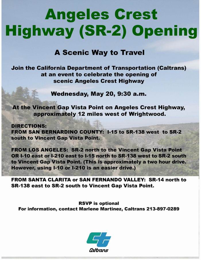
Angeles Crest Highway will reopen on May 20th @ 12:00 noon.
There will be a ribbon cutting ceremony @ Vincent gap to celebrate the event.
There will be a ribbon cutting ceremony @ Vincent gap to celebrate the event.
-
Hikin_Jim

- Posts: 4688
- Joined: Thu Sep 27, 2007 9:04 pm
I feel a hike from Dawson Saddle coming on...
Or maybe just a quick hop up the service road (my preferred route) to Little Jimmy. Woo Hoo!
Or maybe just a quick hop up the service road (my preferred route) to Little Jimmy. Woo Hoo!
-
Richard N.
- Posts: 91
- Joined: Tue Feb 12, 2008 9:47 pm
Jim,
My preferred route to Little Jimmy is right up the draw to Windy Gap. But I must agree, the hike from Dawson Saddle is so sweet. Have a car at Islip for an excellent shuttle hike.
My preferred route to Little Jimmy is right up the draw to Windy Gap. But I must agree, the hike from Dawson Saddle is so sweet. Have a car at Islip for an excellent shuttle hike.
-
Richard N.
- Posts: 91
- Joined: Tue Feb 12, 2008 9:47 pm
Opening ribbon cutting ceremony will be @ Vincent Gap, 12:00 Noon,May 20th
-
Leslie L
- Posts: 46
- Joined: Wed Oct 03, 2007 5:39 pm
I'm wondering about trail conditions along the closed section of highway - is it safe to assume it could it be pretty rough since it's been closed a long time?
-
Hikin_Jim
- Posts: 4688
- Joined: Thu Sep 27, 2007 9:04 pm
Which trail are you referring to?
The trail from Dawson Saddle has been reported as being in decent shape, a couple of minor downed trees and a lot of pine cones on the trail but nothing serious.
The PCT along the ridge top is in good shape and has been used a lot during the road closure.
The trail to Lilly Spring is in disrepair, but that has little to do with the road closure.
-
Leslie L
- Posts: 46
- Joined: Wed Oct 03, 2007 5:39 pm
Hi Jim,
Thanks for the information. HPS describes a use trail from mile marker 66.37 up the gully to Windy Gap. Any info there?
Thanks for the information. HPS describes a use trail from mile marker 66.37 up the gully to Windy Gap. Any info there?
-
Hikin_Jim
- Posts: 4688
- Joined: Thu Sep 27, 2007 9:04 pm
Don't have any info there. Richard N (about 4 posts up on this thread) might know.
-
mtnfox
- Posts: 30
- Joined: Thu Jun 19, 2008 8:54 am
Look at the bottom right corner of this page to see some time lapsed video of the bridge being built:
http://dot.ca.gov/dist07/travel/project ... .php?id=41
http://dot.ca.gov/dist07/travel/project ... .php?id=41
-
Richard N.
- Posts: 91
- Joined: Tue Feb 12, 2008 9:47 pm
Leslie,
The trace trail up the gully to Windy Gap had always been a good quick route to Windy Gap and even Little Jimmy. As far as condition, its what one should expect for a trace trail. But as far as being able to follow it, you should have no trouble with that.
Enjoy your day.
Hike Smart & Hike Safe!!!
The trace trail up the gully to Windy Gap had always been a good quick route to Windy Gap and even Little Jimmy. As far as condition, its what one should expect for a trace trail. But as far as being able to follow it, you should have no trouble with that.
Enjoy your day.
Hike Smart & Hike Safe!!!
-
Leslie L
- Posts: 46
- Joined: Wed Oct 03, 2007 5:39 pm
Hi Richard,
Thanks for the info - I look forward to trying a different route to Windy Gap next weekend.
Leslie
Thanks for the info - I look forward to trying a different route to Windy Gap next weekend.
Leslie
-
Hikin_Jim
- Posts: 4688
- Joined: Thu Sep 27, 2007 9:04 pm
Cool, thanks Richard. I hadn't been up that way for a number of years and didn't want to guess.Richard N. wrote:Leslie,
The trace trail up the gully to Windy Gap had always been a good quick route to Windy Gap and even Little Jimmy. As far as condition, its what one should expect for a trace trail. But as far as being able to follow it, you should have no trouble with that.
Enjoy your day.
Hike Smart & Hike Safe!!!
-
mattmaxon

- Posts: 1137
- Joined: Mon Mar 24, 2008 12:48 pm
-
Hikin_Jim
- Posts: 4688
- Joined: Thu Sep 27, 2007 9:04 pm
And... they're off!!!
The road is now open. Photos: http://www.wrightwoodcalif.com/forum/in ... ic=13858.0 (scroll down).
The road is now open. Photos: http://www.wrightwoodcalif.com/forum/in ... ic=13858.0 (scroll down).
-
Richard N.
- Posts: 91
- Joined: Tue Feb 12, 2008 9:47 pm
I'm heading up right now.
Having dinner in Wrightwood and a quick walk up to Throop from Dawson.
FINALLY!!!!!!
Having dinner in Wrightwood and a quick walk up to Throop from Dawson.
FINALLY!!!!!!
-
Richard N.
- Posts: 91
- Joined: Tue Feb 12, 2008 9:47 pm
I took a drive up the Crest from La Canada yesterday afternoon. The big sign as you get off the 210 freeway as well as the small signs, one just before you enter the forest and one just before Switzers all read Road Closed @ Islip Saddle.
It shows that L.A. County has no idea what San Bernadino County Cal-Trans is doing. As crazy as it is, the section of road re-opened yesterday is in L.A. County but cared for by San Bernadino County. Go figure??? The resurfacing being done by SB County, only goes to the end of L.A. County line??? Now that's crazy!!
The road has been resurfaced, has many miles of new guard rails and, about a mile from Vincent Gap, there is a terrific new bridge. There a really nice waterfall just to the west of the bridge as well.
As I was about to set off on a little walk up Lewis, a car pulls up and its brian90620 and his girlfriend. Nice to meet you both. We enjoyed a little chat and I headed up the hill. When I arrived at Vincent Gap, there were no longer any dignitaries. Good for me eh??
There were many motor bikes enjoying the first day back on this stretch of road. Of course there were motor cars as well.
I enjoyed a nice dinner in Wrightwood and then headed back over the Crest @ 8:45pm. I saw one deer on the road and 2 owls swooped down near the car. Night driving up there is really cool.
The road in great condition. Come up for a drive!!
Photos...
#1 The Sign as you exit the 210 Freeway
#2 Islip Saddle - The Gate is OPEN
#3 Angeles Crest Bridge - BR. No. 53-3029
-
brian90620

- Posts: 123
- Joined: Sun Jan 27, 2008 8:34 pm
It was nice meeting you too and thanks for all the information about wildlife and hiking in the area. We had an excellent time on the crest as usual except this time was better since the road was open.Richard N. wrote: As I was about to set off on a little walk up Lewis, a car pulls up and its brian90620 and his girlfriend. Nice to meet you both. We enjoyed a little chat and I headed up the hill.

-
Taco

- Snownado survivor
- Posts: 6208
- Joined: Thu Sep 27, 2007 4:35 pm
Some funny stuff. 
It must've come off the USS Walke (DD416): http://en.wikipedia.org/wiki/USS_Walke_(DD-416)
It must've come off the USS Walke (DD416): http://en.wikipedia.org/wiki/USS_Walke_(DD-416)
-
HikeUp

- Posts: 4081
- Joined: Thu Sep 27, 2007 9:21 pm
Go to...
http://www.dot.ca.gov/cgi-bin/roads.cgi
and enter "2" for the highway number. Closed just west of Big Pines Highway (west of Wrightwood).
http://www.dot.ca.gov/cgi-bin/roads.cgi
and enter "2" for the highway number. Closed just west of Big Pines Highway (west of Wrightwood).
This highway information is the latest reported as of Saturday, August 29, 2009 at 06:44 .
SR 2
[IN THE SOUTHERN CALIFORNIA AREA]
IS CLOSED FROM 2.2 MI EAST OF THE EAST JCT OF I 210 TO
1 MI WEST OF ANGELES FOREST HWY (LOS ANGELES CO) - DUE TO A WILDLAND FIRE
- A DETOUR IS AVAILABLE
IS CLOSED 2.3 WEST OF THE LOS ANGELES/SAN BERNARDINO CO LINE - DUE TO A
WILDLAND FIRE - MOTORISTS ARE ADVISED TO USE AN ALTERNATE ROUTE
ALL TRACTOR-SEMI TRAILER COMBINATIONS WITH 3 AXLES OR GREATER ARE
PROHIBITED FROM THE JCT OF I 210 /IN LA CANADA-FLINTRIDGE/ TO THE
ANGELES FOREST HIGHWAY (LOS ANGELES CO) - ALTERNATE ROUTES ARE AVAILABLE
-
Mike P

- Posts: 1005
- Joined: Tue Oct 02, 2007 10:48 pm
So...if I'm reading this correctly, the middle section of Hwy 2 is still open but is only accessible by the Angeles Forest Highway??
The eastern closure: Is this due to a different brush fire that is not in the news?
The eastern closure: Is this due to a different brush fire that is not in the news?
-
solar

- Posts: 14
- Joined: Fri Aug 21, 2009 9:08 pm
Forest "kinda" closed too:
Forest Order
http://www.fs.fed.us/r5/angeles/orders/ ... 082809.pdf
Both Lower and Upper and Big T closed as well:
http://dpwgis.co.la.ca.us/website/roadclosures/main.cfm
Bummer- was hoping to tromp around the high country for my last days of vacation. Wishing safety upon the crews...
(First post- what up y'all!)
-
edenooch

- Posts: 504
- Joined: Fri Jul 03, 2009 7:42 pm
But tacodelrio said he would buy a pitcher of 1903 at Newcomb Ranch 
-
Taco
- Snownado survivor
- Posts: 6208
- Joined: Thu Sep 27, 2007 4:35 pm
It appears I'll do anything to get out of paying for a pitcher of Springfield 1903...