
East Fork to Baldora / Widco Mine

-
EnFuego

- Posts: 677
- Joined: Mon Dec 15, 2008 11:14 am
Nice TR. Thanks for sharing that. Your TR brought back a lot of memories from when my dad and I explored those same mines about 25 years ago.
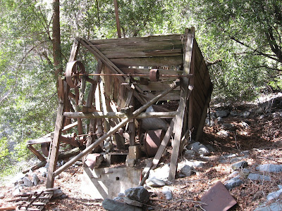
I love the picture of the shack. I love finding old remnants like that.
I love the picture of the shack. I love finding old remnants like that.
-
AW~

- Posts: 2093
- Joined: Mon Oct 01, 2007 12:00 pm
Neat...far away stuff. I think you guys could easily do Stanley-Miller in a day. Probably bag Iron too like the HPS archive TR.
-
Taco

- Snownado survivor
- Posts: 6136
- Joined: Thu Sep 27, 2007 4:35 pm
Cool photos. Is that ranch very active?
-
Ze Hiker

- Posts: 1432
- Joined: Mon Jul 28, 2008 7:14 pm
dunno for sure, didn't see anyone, but there was a car down there, looks like the place is being kept up.
-
Phil B
- Posts: 101
- Joined: Wed Oct 03, 2007 12:47 pm
Hi Ze,
I saw you guys approaching the Saddle as I was on my way back from Iron Mountain, looks like you had a pretty good time out there and your pics were great.
There is another mine out that way called Eagle, I was descending the San Antonio Ridge about 8 years back and took shelter there during a storm. it still had the old equipment like Pumps and crushers that they use to use. these places are so fascinating, did see any shafts at Baldora or are they filled in?
Cheers Phil
Pics from Iron Mountain http://philbrown.smugmug.com/gallery/75 ... 4471_zLdsX
-
Ze Hiker
- Posts: 1432
- Joined: Mon Jul 28, 2008 7:14 pm
Hi Phil,
Nice meeting you on the trail.
I'd love to check out Eagle and Gold Dollar mine areas, maybe on a ridge traverse excursion. I did not see any shafts at Baldora/Widco, I looked around a bit, so they were not obviously. But maybe I needed to look around more.
Nice meeting you on the trail.
I'd love to check out Eagle and Gold Dollar mine areas, maybe on a ridge traverse excursion. I did not see any shafts at Baldora/Widco, I looked around a bit, so they were not obviously. But maybe I needed to look around more.
-
outwhere

- Posts: 323
- Joined: Sun Jan 25, 2009 5:40 pm
Very cool TR, Ze...
I don't know anything about these mines, so I was wondering, this Widco mine, does it have anything to do with Allison mine?
Also curious, I love any and everything about old structures that are still standing in the SG Mts. - especially the ones way off the beaten path.... are there that many still standing, whether they be cabins or mine shacks??? Thanks in advance if you have any answers on this...
-
Hikin_Jim

- Posts: 4688
- Joined: Thu Sep 27, 2007 9:04 pm
Nice hike! Is it really 5000+ gain RT? I didn't realize it was that much.
Wow, the trail from Heaton Saddle down to Coldwater Canyon is really beat up. It was in much better shape when I went down it last. Interestingly, if you look at the sign at the start of the Heaton Flats Trail, it still lists Coldwater Canyon as a destination. Obviously, not many are going down there any more, particularly since you can't exit via Coldwater Canyon these days.
That cabin that you were standing in front of is the cabin I was refering to that someone had restored at some time. It's in obviously better shape than the rest of the relics at the mine. It was pretty intact when I was there, but obviously time has taken its toll.
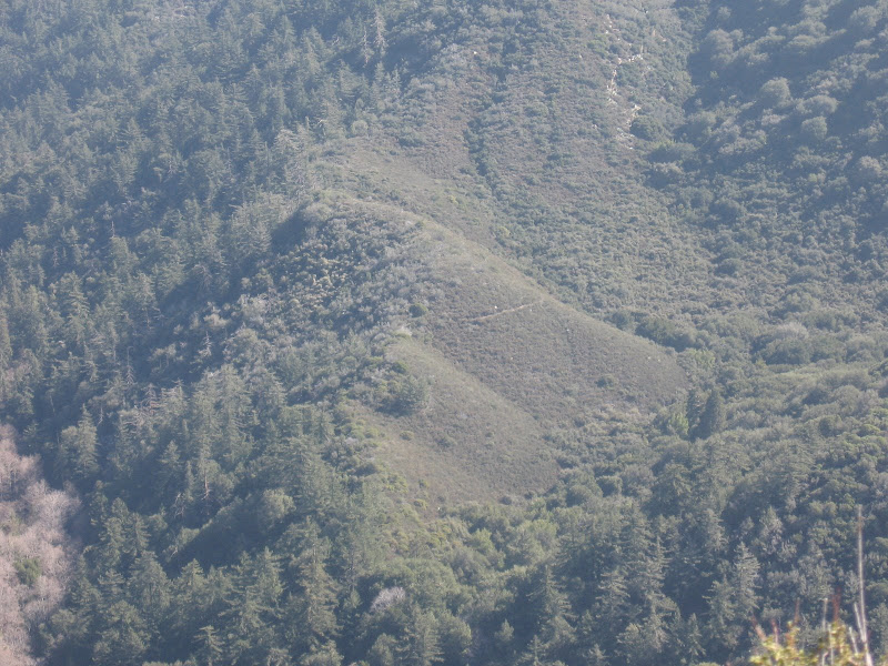
QUESTION: What are we we looking at in the below picture? I think you're looking across the canyon from the Heaton Flats trail, yes? Is that trail we can see in the photo the trail down to Coldwater Canyon or that trail something else? I've seen photos of a trail on the far side (East side) of Coldwater Canyon, and I've always been intrigued by what that might be -- perhaps part of the old route to Baldy via Big Horn Ridge? Inquiring minds want to know.
The old route to Baldy via Big Horn Ridge started near where the trail that you took comes into the canyon. I have one old 15' series map that shows the old trail. I'll have to scan it and post it some time.
Also, when you say there are two mines marked on your map, do you mean the two shafts marked on this map?
Wow, the trail from Heaton Saddle down to Coldwater Canyon is really beat up. It was in much better shape when I went down it last. Interestingly, if you look at the sign at the start of the Heaton Flats Trail, it still lists Coldwater Canyon as a destination. Obviously, not many are going down there any more, particularly since you can't exit via Coldwater Canyon these days.
When I've been to the Baldora, I saw no intact shafts. There were multiple intact shafts at the Stanley-Miller when I went there.Zé wrote:I did not see any shafts at Baldora/Widco, I looked around a bit, so they were not obviously. But maybe I needed to look around more.
That cabin that you were standing in front of is the cabin I was refering to that someone had restored at some time. It's in obviously better shape than the rest of the relics at the mine. It was pretty intact when I was there, but obviously time has taken its toll.
QUESTION: What are we we looking at in the below picture? I think you're looking across the canyon from the Heaton Flats trail, yes? Is that trail we can see in the photo the trail down to Coldwater Canyon or that trail something else? I've seen photos of a trail on the far side (East side) of Coldwater Canyon, and I've always been intrigued by what that might be -- perhaps part of the old route to Baldy via Big Horn Ridge? Inquiring minds want to know.
The old route to Baldy via Big Horn Ridge started near where the trail that you took comes into the canyon. I have one old 15' series map that shows the old trail. I'll have to scan it and post it some time.
Also, when you say there are two mines marked on your map, do you mean the two shafts marked on this map?
-
Ze Hiker
- Posts: 1432
- Joined: Mon Jul 28, 2008 7:14 pm
outwhere wrote:Very cool TR, Ze...
I don't know anything about these mines, so I was wondering, this Widco mine, does it have anything to do with Allison mine?
Also curious, I love any and everything about old structures that are still standing in the SG Mts. - especially the ones way off the beaten path.... are there that many still standing, whether they be cabins or mine shacks??? Thanks in advance if you have any answers on this...
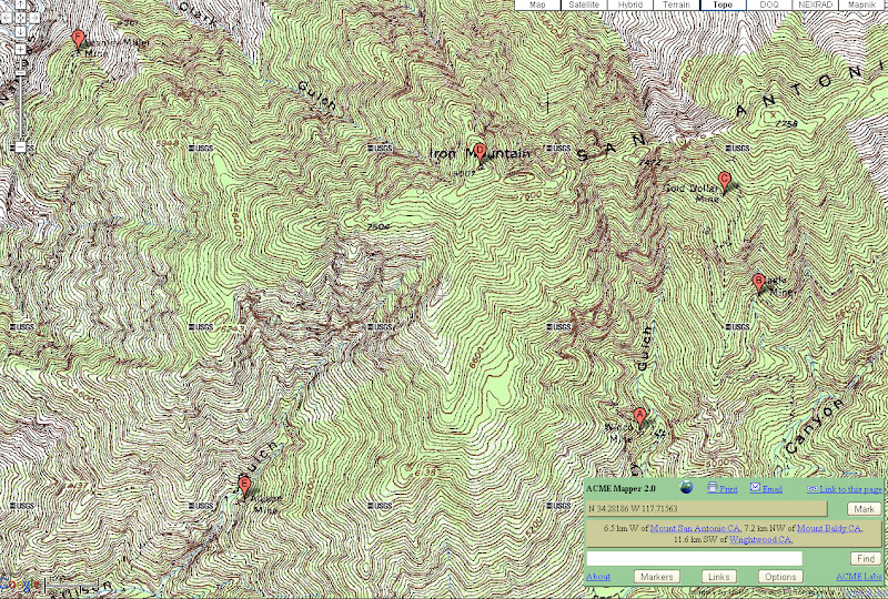
It (A) is on the SE side of Iron Mt, while Allison is on the SW side (E). Stanley Miller Mine (F) is on the NW side. Gold Dollar and Eagle mine are pretty close to Baldora/Widco.
I don't know about structures at other mines in the San Gabriels. I would check out this site:
Also John Robinson has a book "mines of the san gabriels". I'm getting that.
-
Ze Hiker
- Posts: 1432
- Joined: Mon Jul 28, 2008 7:14 pm
Yeah, it's about 3000 just getting to the saddle, then up to another 1000 up from Coldwater Canyon up to the mines, and another 1000 on the way back (500 on the washed out trail, 500 on Heaton flat trail). I think the parts up Dry Gulch and on the washed out trail don't seem like much since it is slow gaining anyways.Hikin_Jim wrote:Nice hike! Is it really 5000+ gain RT? I didn't realize it was that much.
Wow, the trail from Heaton Saddle down to Coldwater Canyon is really beat up. It was in much better shape when I went down it last. Interestingly, if you look at the sign at the start of the Heaton Flats Trail, it still lists Coldwater Canyon as a destination. Obviously, not many are going down there any more, particularly since you can't exit via Coldwater Canyon these days.
That cabin that you were standing in front of is the cabin I was refering to that someone had restored at some time. It's in obviously better shape than the rest of the relics at the mine. It was pretty intact when I was there, but obviously time has taken its toll.
QUESTION: What are we we looking at in the below picture? I think you're looking across the canyon from the Heaton Flats trail, yes? Is that trail we can see in the photo the trail down to Coldwater Canyon or that trail something else? I've seen photos of a trail on the far side (East side) of Coldwater Canyon, and I've always been intrigued by what that might be -- perhaps part of the old route to Baldy via Big Horn Ridge? Inquiring minds want to know.
The old route to Baldy via Big Horn Ridge started near where the trail that you took comes into the canyon. I have one old 15' series map that shows the old trail. I'll have to scan it and post it some time.
Also, when you say there are two mines marked on your map, do you mean the two shafts marked on this map?
Yeah, that trail requires some good comfort handling unstable terrain. I personally was fine with it although some others were more affected.
Ok I updated your map.
I wasn't clear in my original TR....it was my garmin map that showed separate locations for Baldora and Widco. Widco is where you placed it "A". The shack for it is a bit lower, about "C".
The Baldora one is further up. The shack and equipment are located at about "D", and the supposed location of the mine is at "E". So I saw two locations with stuff. I'm not sure this site is visited as much because it is not on the USGS topo. But to me it would define Baldora and Widco as separate mines!
"F" appears to be that segment of trail in the photo (check the satellite view). On the east side of the canyon. Have to check how that fits with your coordinates for the old trail. Very cool to see any remains of it.
-
Hikin_Jim
- Posts: 4688
- Joined: Thu Sep 27, 2007 9:04 pm
Baldora
Interesting about the items further up Dry Gulch in the vicinity of point "D." I don't think I've visited those. What map are you looking at? The USGS topo doesn't show them -- at least the one I have.
Looking at Hugh Blanchard's site (may he R.I.P.), I see he has a picture of a "Baldora Tunnel." I remember finding something in the way of a shaft but that it was so collapsed I didn't want to go in. It did not look like that downward pointing tunnel in Mr. Blanchard's photo.
Regarding point "B" on your map, did you head up there at all? That shaft is higher up the hill side. I didn't visit that shaft when I was there.
Big Horn Ridge
Yes, that trail segment in your photo is very intriguing. It looks like someone has been keeping it up. There's no way it would be in that kind of shape if it hadn't been used since the times when Weber Camp was a going concern. I've been wanting to check that out. I'll try to scan the map that has the trail marked this weekend.
If you go to the Big Horn Ridge thread, you'll see other photos of that segment of trail in a link in one of the postings. This photo in particular is intriguing. The satellite photo of that area isn't as clear as your photo, but it does look like something is there, possibly extending as far as "B" on the above link.
-
Ze Hiker
- Posts: 1432
- Joined: Mon Jul 28, 2008 7:14 pm
If this is a stamp mill

then I assume this is also. This was at "C".

This location is noted on my Garmin map, in Mapsource. I haven't checked if its on other maps. But it is accurate.
I did not head up to point B, unfortunately. I should have, for some reason wasn't thinking that the shaft was even further up. Oh well.
Yes I agree on the BH ridge. And to me it does seem like that trails continues into the brush a bit. Very interesting. Maybe I'll get a decent look down if I make it up the ridge this weekend. I'll try to get up past 6000 ft to look down.
then I assume this is also. This was at "C".
This location is noted on my Garmin map, in Mapsource. I haven't checked if its on other maps. But it is accurate.
I did not head up to point B, unfortunately. I should have, for some reason wasn't thinking that the shaft was even further up. Oh well.
Yes I agree on the BH ridge. And to me it does seem like that trails continues into the brush a bit. Very interesting. Maybe I'll get a decent look down if I make it up the ridge this weekend. I'll try to get up past 6000 ft to look down.
-
Hikin_Jim
- Posts: 4688
- Joined: Thu Sep 27, 2007 9:04 pm
Looks like a stamp mill to me.
I'd be interested if you see anything.Zé wrote:Yes I agree on the BH ridge. And to me it does seem like that trails continues into the brush a bit. Very interesting. Maybe I'll get a decent look down if I make it up the ridge this weekend. I'll try to get up past 6000 ft to look down.
Are you guys going to try to go all the way to the summit of Baldy? Very cool.
-
Ze Hiker
- Posts: 1432
- Joined: Mon Jul 28, 2008 7:14 pm
Not going all the way up (for now). Just seeing if we can get up, and if so maybe go up to about 6300 ft bump. Check out the brush.
If good, next time go the whole way up. Head down to Bear Flats. That will be a good one.
If good, next time go the whole way up. Head down to Bear Flats. That will be a good one.
-
Hikin_Jim
- Posts: 4688
- Joined: Thu Sep 27, 2007 9:04 pm
Oh, yeah.Zé wrote:If good, next time go the whole way up. Head down to Bear Flats. That will be a good one.
Just for fun, here's a link to the UTM trace of the old trail based on hand calculationis plotted on my old map that I posted when the Baldy via BHR thread first started: https://eispiraten.com/f ... asc-29.php.
I'll try to scan the map this weekend.
-
outwhere
- Posts: 323
- Joined: Sun Jan 25, 2009 5:40 pm
Thanks for that info Ze - cool pictures, never knew there were that many mines in that area....
I have the John Robinson SGM coffee table book ---- and remembered hearing about his books, specifically on mines. Time to break that one out again, should pick up the mine book too....
Hate to ask like this,,,, but is John Robinson still with us?
I will always be grateful for the three books he did on our 3 main mountain ranges. Instant and all time classics...