Rattlesnake Peak: 12-06-2008

TRs for the San Gabriel Mountains.
Post Reply
User avatar
HikeUp
Posts: 3861
Joined: Thu Sep 27, 2007 9:21 pm

Post by HikeUp »

Hiked up to Rattlesnake Peak on Saturday morning via the Sierra Club standard route. Nice weather for a tough hike - 70's max, and some high clouds obscured the direct sun near the end of the hike. In addition, the clear skies provided incredible views from the heart of the San Gabriels - gotta love 'em!

The use trail is in great shape, i.e. not overgrown, and easy to follow. There were a bunch of first timers on this trail today and no one had any issues following the trail as far as I know.

On my descent, as I was sliding down from the use trail to the road, a group of people were walking by and one guy asked me "what the hell are you doing 'up there'...because it's there?"

I said "Yes".

Dumbass.

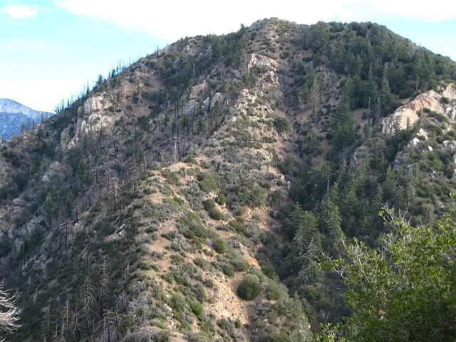
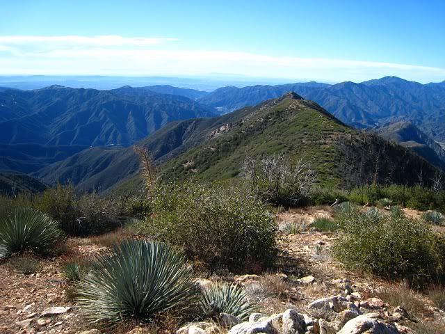
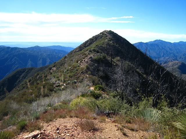
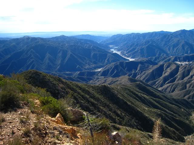
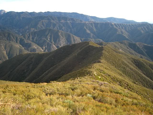
A view of Rattlesnake Peak from over on the trail to Iron Mt. (from last February)...
Image

A view of Iron Mt. and others from Rattlesnake...
Image

Looking up towards Rattlesnake on the ascent...
Image

If you look really, really, really close, Tim Le is in this picture. He had passed me a few minutes earlier while I stopped to down a gatorade. Also ran into a few others from this forum, including Taco and Joe. Taco was hardly breaking a sweat - bastard. :D

I estimate this hike to be between 8.5 to 9 miles roundtrip and about 4000' total gain roundtrip. I've seen estimates of anywhere from 3500' to 4400' total gain. Obviously the 3500 is wrong because it's less than the difference between the peak and the trailhead, but 4400' seems to be a bit much. Anyone know a more definitive set of numbers?

p.s. the Sierra Club should really read their own route descriptions more carefully...
Make careful note of your route on the way to the summit as it is easy to make a mistake on the return trip. Make sure you go down the ridge to the west-southwest that starts at bump 4040'. There is a steel post marking this spot.
The steel posts are at about 4100' (one bump further up the ridge) and there is no ridge that heads "west-southwest" from bump 4040' (you'd end up falling down a steep slope heading that way)...the options on the way down at pt. 4040' are to head south (not the right way) or east (the right way).
User avatar
AW~
Posts: 2043
Joined: Mon Oct 01, 2007 12:00 pm

Post by AW~ »

Would you happen to have any pictures of Devils Gulch from the summit? I was wondering what would be involved to get there from Rattlesnake to make a loop out of it...there looks to be a NE ridge that eventually connects to some old trail to Devil Gulch.
User avatar
HikeUp
Posts: 3861
Joined: Thu Sep 27, 2007 9:21 pm

Post by HikeUp »

Sorry AW, nothing looking down into Devil Gulch or the NE ridge.

One shot looking towards South Hawkins (can you drop into Devil Gulch from the ridge that goes that way?)...
Image

Looking north from Rattlesnake, but tilted upwards...
Image

And just for fun, Twin Peaks...
Image
User avatar
AW~
Posts: 2043
Joined: Mon Oct 01, 2007 12:00 pm

Post by AW~ »

nice shot of s.hawkins....not a whole lot of info on Devil Gulch out there....yeah in almost all cases its not credible to enter into a SG canyon/drainage at or near the very top...with most of the good stuff at or near the end of the canyon/drainage...one hiker had told me there was a 30ft waterfall thus prohibiting exploration from the bottom...thing I dont like most about this area is all the dayhikes are really long..tough call to say what can be done in a day and what cant...unless ya got the speed and V8 engine which I dont have.
User avatar
Taco
Snownado survivor
Posts: 6011
Joined: Thu Sep 27, 2007 4:35 pm

Post by Taco »

Most excellent!

I'll add photos soon as I didn't get enough hours of work. :?

Edit: Nevermind, it appears I can't load any photos from that trip onto Photof*ckit. Fantabulous. Love it.
User avatar
Tim
Posts: 560
Joined: Tue Apr 08, 2008 8:55 pm

Post by Tim »

Hey HikeUp, that was you? Sorry, I didn't know, I would have stopped longer to chat! Nice meeting you, though!

I ended up continuing on to the west ridge. That descent was wild. I was on the little peaklet west of Rattlesnake and watched through my binoculars as Joe and his group made it to the top. I blew my whistle but it didn't seem they heard it. South Hawkins was too far to attempt with the time I had left, so I went south and explored that ridge till it ended. Nice little adventure but the bushwhacking was nonstop. I got battered by every sharp, thorny plant imaginable!
User avatar
HikeUp
Posts: 3861
Joined: Thu Sep 27, 2007 9:21 pm

Post by HikeUp »

Tim, I only figured out it was you by reading the register when I finally summited...
Image

Congrats on your 1st time to Rattlesnake. Having found several of your register entries this year I guess it was only a matter of time until we crossed paths. Too bad you caught me just as I needed a gatorade break, otherwise we'd of probably figured it out. I'll recognize you next time :D
User avatar
JMunaretto
Posts: 370
Joined: Thu Feb 07, 2008 11:03 am

Post by JMunaretto »

Here is my trip report contribution
User avatar
Taco
Snownado survivor
Posts: 6011
Joined: Thu Sep 27, 2007 4:35 pm

Post by Taco »

Tim, did you head out to Peak 5021 AKA Doe Peak?
Link: http://www.summitpost.org/mountain/rock ... Peak-.html

Nice TR, Joe!
User avatar
Tim
Posts: 560
Joined: Tue Apr 08, 2008 8:55 pm

Post by Tim »

Thanks HikeUp and congrats on making up there as well.
TacoDelRio wrote:Tim, did you head out to Peak 5021 AKA Doe Peak?
Yep, that's the one! Cool, nice to know it has a name (even if it's unofficial).

Some photos...

West face of Rattlesnake:
Image

View looking south at the ridge that leads to Doe Peak:
Image

Approaching Doe Peak:
Image

Looking east at the divot in the Rattlesnake South Ridge:
Image

I continued about 100 ft beyond Doe Peak to get this shot of the San Gabriel and Morris Reservoirs:
Image

Heading back down the Rattlesnake South Ridge just before you make the turn east. The late afternoon sun always makes things look nice:
Image
User avatar
Taco
Snownado survivor
Posts: 6011
Joined: Thu Sep 27, 2007 4:35 pm

Post by Taco »

Excellent! I haven't been on that ridge yet. Looks cool. That divot interested me as well, and I've been taking photos of it for a few months now.
User avatar
Hikin_Jim
Posts: 4686
Joined: Thu Sep 27, 2007 9:04 pm

Post by Hikin_Jim »

JMunaretto wrote:Here is my trip report contribution
Nice TR. Nice photos (as usual) too.

The link from your TR to your photos didn't work quite right. The link got me to your Picasa account but not to the Rattlesnake Pk photos. Don't know if you care, but your link: http://picasaweb.google.com/jmunaretto/ ... Dec%202008#
should be changed to:
http://picasaweb.google.com/jmunaretto/ ... eakDec2008#

For the trivia buffs out there:
Shoemaker Rd was actually the second attempt to put a road up the E Fork.

The first attempt, made by the CCC in 1936 went up the canyon bottom from Heaton Flats and included the Bridge to Nowhere and the tunnel (now mostly collapsed) just beyond the bridge. The great flood of March 1 - 2, 1938 damaged the road so badly that it was abandoned while still under construction.

The second attempt (1954 to 1969) was Shoemaker Rd which was intended to be an escape route in the event of nuclear attack and was slated to go up the west side of the canyon. Shoemaker was eventually abandoned after 15 years of work due to lack of progress (because of the difficulty of the terrain), budget constraints, and environmental concerns.

I believe that Hwy 39 was also intended to be used as an escape route. The upper portion of Hwy 39 was opened in 1961 but was plauged by landslides. The upper portion of the road was finally closed in 1978. Supposedly, CalTrans has at long last obtained funding to reopen Hwy 39. Honestly, judging by the looks of the west slope of Mt. Islip I think they'd be wasting their money, particularly at a time when budget shortfalls are at crisis levels. It would be cool though to have an alternate route up to the middle high country. CalTrans claims to have figured out a way to mitigate slides. I'm not so sure about that, but, to their credit, CalTrans has been able to keep a single lane open for emergency vehicles.
User avatar
AW~
Posts: 2043
Joined: Mon Oct 01, 2007 12:00 pm

Post by AW~ »

>The great flood of March 1 - 2, 1938 damaged the road so badly that it was abandoned while still under construction.

Or at least thats how its gone down...me thinks it was just rain, and there was no godzilla 30+ft high flash-flood...although it makes for a better story. Anyways 30+ inches of rain over 5 days in that storm.

source:
http://www.wrh.noaa.gov/sgx/document/weatherhistory.pdf

Most rain in 1 day:
26.12 inches on slopes of Mount Wilson(Hoegees campground)
January 23, 1943

although Taco might be interested in 1969..."Heavy snow in mountains approach greatest depths on record"

Joseph, legs look fine for such a trip...you walking right behind someone? :D

nice pics all around :D
User avatar
Hikin_Jim
Posts: 4686
Joined: Thu Sep 27, 2007 9:04 pm

Post by Hikin_Jim »

Interesting link. From the link:
WEATHER
Storm of tropical origin. 11.06” at LA.
More than 30” at several mountain
stations of San Gabriel and San
Bernardino Mountains (32.2” at
8,300’ elev.). More than 22” in the
Santa Ana River headwaters.
Considerable snow was melted,
adding to the runoff. This led to
unprecedented flood control efforts,
including a network of dams and
canals and concrete channels.

ADVERSE IMPACTS
210 reported dead or missing in
flooding across Southern
California. 45 in Orange County, of
which 43 perished in Mexican-
American Atwood from an 8 ft.
wall of water. Hundreds injured.
Santa Ana River floods, inundates
nearly all of northern Orange
County
. Catastrophic damage to
more than 1,500 residences. 400
cabins and buildings washed away
in and around San Antonio
Canyon
. Whitewater River floods,
isolates Palm Springs.
Sounds pretty severe to me! :shock: I understand that there had been some fires prior to the flood. Burn areas + heavy rain = not good. I believe the '38 flood was the reason they closed the Mt. Lowe Railway. As I recall, it was heavily damaged, and one man died at the Rubio Canyon station.

If 400 cabins and buildings were washed away in and around San Antonio Canyon, then I can easily believe that things were equally bad or worse in the nearby N Fork of the SG River.
User avatar
AW~
Posts: 2043
Joined: Mon Oct 01, 2007 12:00 pm

Post by AW~ »

It does interest me as there is a possibility of such a flashflood. Heres an image from Flickr:

Image

I wonder how the rock on the left got there. Normally I would think it rolled down from above but the terrain above renders that extremely unlikely. So then was there a flashflood that dropped it off that high? In 1938? Im sceptical. Thats one heavy rock to go floating.Another thought is that the indians who lived here set it up or miners set it up...doubt it will get resolved...can you imagine a water level that high though? :shock:
User avatar
Bill
Posts: 332
Joined: Thu Jul 24, 2008 6:09 pm

Post by Bill »

AW wrote:It does interest me as there is a possibility of such a flashflood. Heres an image from Flickr:

Image

I wonder how the rock on the left got there. Normally I would think it rolled down from above but the terrain above renders that extremely unlikely. So then was there a flashflood that dropped it off that high? In 1938? Im sceptical. Thats one heavy rock to go floating.Another thought is that the indians who lived here set it up or miners set it up...doubt it will get resolved...can you imagine a water level that high though? :shock:
Actually, water in sufficient volume, and speed has tremendous power. We have a road here in Wrightwood that is regularly blocked by hugh rocks, that seem too large to come down from the flow of water.
It's in the thousands of pounds per square inch depending on the flow I believe. As far as height, I guess it would depend on rate per hour or minute. It probably road on top of other rocks, and happened to perch in that position. I would think water would be a more likely cause than Indians.
Im no expert, but I did stay in a Holiday Inn Express last night. :lol: :lol:
User avatar
simonov
Posts: 1087
Joined: Tue Nov 27, 2007 5:44 pm
Location: Reno, NV
Contact:

Post by simonov »

AW wrote:>The great flood of March 1 - 2, 1938 damaged the road so badly that it was abandoned while still under construction.

Or at least thats how its gone down...me thinks it was just rain, and there was no godzilla 30+ft high flash-flood...although it makes for a better story.
I'm not sure why you would doubt it. The 1938 flood was the most destructive natural disaster in SoCal history.

Here's an Anaheim neighborhood following the flood:

Image

This is Huntington Beach as seen from Adams St in Costa Mesa. I bet a lot of Huntington Beach residents would be surprised to learn they live in a floodplain:


No one even knows how many Mexican families were washed away from Orange County colonias; dozens, at least. It was a terrible flood.

The 1969 floods (which I personally remember) washed away a few homes in Anaheim and Santa Ana, after which the Army Corp of Engineers tamed the Santa Ana River once and for all.
Nunc est bibendum
User avatar
Hikin_Jim
Posts: 4686
Joined: Thu Sep 27, 2007 9:04 pm

Post by Hikin_Jim »

I believe that rock probably was deposited by water. In the bottom of a canyon with every wall, cranny, and creek shedding water, water flows can get very very high. The stream bed may have been cut down further subsequent to the rock's deposition, but streams do flow that high upon occasion.
User avatar
HikeUp
Posts: 3861
Joined: Thu Sep 27, 2007 9:21 pm

Post by HikeUp »

Apropos of almost nothing, granite submerged in water weighs about 2/3rds of what it weighs out of water.

I agree with HJ's hypothesis.

It's quite interesting to watch (and to listen to!) Eaton Canyon wash during/after a huge rain. I've seen rather large boulders (although nothing the size of what's in AW's pic) seemingly float down stream.
User avatar
HikeUp
Posts: 3861
Joined: Thu Sep 27, 2007 9:21 pm

Post by HikeUp »

AW wrote:Would you happen to have any pictures of Devils Gulch from the summit? I was wondering what would be involved to get there from Rattlesnake to make a loop out of it...there looks to be a NE ridge that eventually connects to some old trail to Devil Gulch.
Dunno if this picture of Devils Gulch helps ya or not.

Part of a good description of the route from Rattlesnake to South Hawkins.
User avatar
AW~
Posts: 2043
Joined: Mon Oct 01, 2007 12:00 pm

Post by AW~ »

Thanks for that link...he has some nice nice pictures of others as well.
Devils Gulch I think is off my list for this year since I dont get out much.
Also,Im thinking this may be one to go from the bottom as it may have little value.
Post Reply