MikeSash wrote:Here in Palmdale (2000 ft) we got hammered! I can only imagine what our side of the SG's got. Probably 7-8 inches where I live, snowed all day and only stopped about an hour ago. I've never seen snow fall like this in Palmdale. You can go outside and listen for about 5 minutes before you hear a tree limb crack and break under the foreign weight.
I feel yah, Mike.
Be careful out there, drivers are nuts under normal weather conditions in Palmdale.
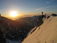
Went up baldy Wed. night and woke up to a white wonderland under warm blue skies. The snow was deep and soft; even with snowshoes! Although the seasons was late to start, it was worth the wait! See pictures below.
Currently (Friday morning) shows snow on the east ridge of Josephine which is around 5200' - 5500' - similar to Mt. Lowe. I'd guess west ridge of Brown is mostly clear except in well shaded areas and the north side of Lowe has plenty of snow on the mostly shaded trail. Whether that snow is packed down and icy depends on how many boots have gone over the trail.
Thursday morning the snow was down to about 3600' but it was well over 4500' by Thursday afternoon - as seen from Pasadena.
This morning there was snow, visible from La Crescenta, about 500' below the summit of Mt. Lukens (which is just over 5000').
yesterday from the freeways
tujunga - as matt said snow level 5000ft
front range - snow mt lowe but not muir peak...not sure what the elevation is at those parts...snow at inspiration point was the lowest.
asuza-hawkins,etc blanketed...monrovia peak within 200-500ft of the summit.
glendora - nothing.
Baldy&Lytle Creek...white...but not that much at Baldy compared to Lytle.
San Bernandino - much more than San Gabriels..not sure what peaks are there but one of them I assume to be San Gorgino from the freeway was well covered all the way down to about elevation 3500. nice drive though.
San Jacinto-sunny side had steady snow coverage to about 1000ft above the freeway
did a hike in Catherderal City...non sunny side of San Jacinto white and pretty....lite grass turned green real quick and rocks have a good degree of color.
glamisking wrote:Went up baldy Wed. night and woke up to a white wonderland under warm blue skies. The snow was deep and soft; even with snowshoes! Although the seasons was late to start, it was worth the wait! See pictures below.
Nice cam link. I now have a new screen background.
I drove by Mt. Lukens this morning. I was thinking about 4500' for the snow level. Just another corroborating observation.
Worth noting is the fact that it is very sunny here in the San Gabriel Valley today (think melting). Tonight will be pretty cold up there (think refreezing). Watch out for ice. You can probably bypass most stuff, and a lot of the trails will still be untracked (and therefore less icy), but watch out for ice.
Wow, never knew about that cam. Looks like I have another one to check obsessively besides Mt. Wilson. The pic I see right now is dated 12/19 @10am. If you click on the "24 hour image sequence" tab, it sure as heck looks better than their "pristine" sample.
Driving down the 210 yesterday, it looked like a dusting on Henninger Flats.
Was thinking of taking my 5 year old for his first real snow experience. As I live by LAX, would like to avoid the drive to the San Bernardino Mountains. Any suggestions in the San Gabriels? I was thinking about the Manker Flats area...or do you think I should head up Hwy 2 (from the west)?
If it were me, I'd go up Angeles Crest Hwy. Manker Flats is great, but the road is narrow and windy (seriously hardcore turns), and it'a a fairly small place. It's going to be a zoo. A very dangerous zoo.
ACH is a better drive. You still need to take it slow and watch for ice, but there's a whole lot more room up there to spread out. Just keep driving till you see good snow and good parking.
The CHP may still be requiring snow chains on your drive wheels. If they are, they'll turn you back if you don't have them. You might check the CHP website and see what the requirements are.
If the CHP is requiring chains and you don't want to deal with it, you can always drive out to the Palm Springs Tram. Yeah, it's a drive, but it's straight down the 10 from W LA, you go up a pretty straight road that gets a lot of sun, and they whisk you right to the top. The ride itself is pretty cool. Great views on a clear day. It does cost $22 bucks each or something like that, but it's pretty nice up there. Just an option.
I was supposed to go shooting tomorrow near Joshua Tree. I just called the airport and they said there's still a foot of snow everywhere and the roads off highway 62 are pretty treacherous. He said forget about dirt roads.
Anyone have any idea whether that snow will still be there tomorrow? What are my chances on dirt roads with a 1998 GMC Yukon 2WD with chains?
Here are some new snow pics ...............
On Wednesday My gf and I drove up to the Mount Waterman area (right off the road) while it was snowing, to play in the at least 2 and a half feet of fresh powder in the area. There were definitly drifts that were deeper though. It was fun for the most part, but the sledding was not that great due to the new snow not being packed at all.
Pics: http://picasaweb.google.com/brian90620/ ... #slideshow
Also, on Thursday we went to the Cleveland National Forest for a change since there was an incrediable amount of snow there 8) ........ We hiked up Silverado Motorway off Maple Springs road to approx. within a mile of the Main Divide Road (dirt). Above 3000 feet where we were hiking there was about 6 inches of snow, but Im sure there must have been alot more on Santiago Peak.
Pics: http://picasaweb.google.com/brian90620/ ... #slideshow
Thanks for the advice. After reading your comments about the Baldy area...and seeing the story on the 11pm Channel 4 news...I will be avoiding that area and will travel up ACH.
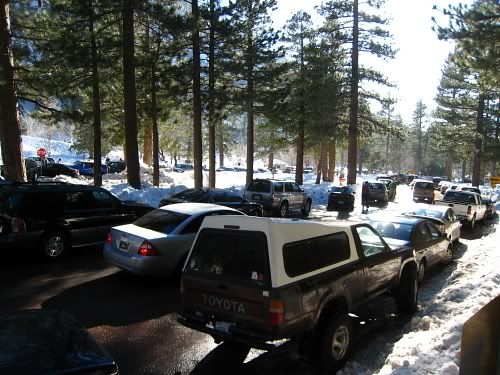
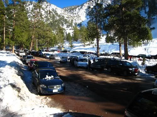
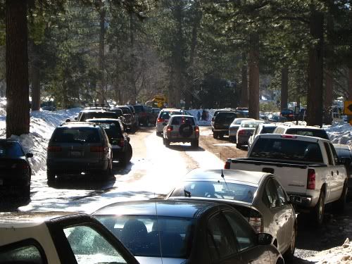
Btw, here's what it looked like at Manker on Saturday at around 3:00pm. There was some traffic going down, but not as bad as I thought (everyone was still playing in the snow). It took half an hour to drive down the mountain. One time I left late and it took me almost 2 hours to get down.
After seeing those photos of Manker Flats...I am so glad we didn't venture up that way.
Instead we parked at Three Points on ACH and played for a while. There were other families there, but not too many people.
Then we drove to Jarvi Vista for lunch and more snow play.
We headed downhill after 2pm and the parking area at Three Points was packed...and gridlock existed in the parking area at Red Box with vehicles trying to leave while others tried to get their parking spots. The parking lot at the top of Switzer's was also full.
But there were still plenty of turnouts with available parking and snow areas for play, and the trip downhill was not bad.
Mt. Waterman had their chairlifts operating, as well.
It was a great day. It makes me want to start snow-shoeing. Thanks again for the warnings to stay away from the Baldy area!
[quote="Hikin_Jim
I see a photo with a person thigh deep in snow. Did one of you not have snowshoes? Or were you postholing like that with snowshoes?
What route did you take to the top? Any signs of snow instability? Any signs of avvies?[/quote]
Hey HJ- sorry I didn't get back to you. I was the only one with snowshoes which kept me sinking between my shins and bottom of my knees. Because he was sinking so deep it really killed our progress. I planned to camp at the bootom of the Ridge Register Route but since it took us about 4 hours to get to the bottom of the Ski Hut trail we changed our plans. Instead be went around the corner from the hut trail and camped right on the road. This is not something I would noramlly do but because it was 4AM and I knew no one would be going up the road and never know we were there.
After 2:30 AM the snow stopped and the moon light up the whole valley. There is nothing which can compare to the traquility of snowshoeing on fresh snow, in the moonlight, without a headlamp!
glamisking wrote:After 2:30 AM the snow stopped and the moon light up the whole valley. There is nothing which can compare to the traquility of snowshoeing on fresh snow, in the moonlight, without a headlamp!
You've got that right. Wow. Sounds really nice.
HJ
P.S. Tell your buddy to rent some 'shoes next time. They're not that expensive to rent.
brian90620 wrote:Here are some new snow pics ...............
On Wednesday My gf and I drove up to the Mount Waterman area (right off the road) while it was snowing, to play in the at least 2 and a half feet of fresh powder in the area. There were definitly drifts that were deeper though. It was fun for the most part, but the sledding was not that great due to the new snow not being packed at all.
Pics: http://picasaweb.google.com/brian90620/ ... #slideshow
Also, on Thursday we went to the Cleveland National Forest for a change since there was an incrediable amount of snow there 8) ........ We hiked up Silverado Motorway off Maple Springs road to approx. within a mile of the Main Divide Road (dirt). Above 3000 feet where we were hiking there was about 6 inches of snow, but Im sure there must have been alot more on Santiago Peak.
Pics: http://picasaweb.google.com/brian90620/ ... #slideshow
Your pics in the Waterman area look really nice. I haven't been able to get up to the mtns,do to holiday shopping (yuck ) but I hope to head up somewhere Wednesday morning for a short, quick hike in the snow.
I also liked the Cleveland Forest pics. I never heard of Maple Springs. Actually, I've never really explored the Cleveland national forest, and I grew up about 5 miles away on the O.C. side. I'll have to put that place on my "To Visit" agenda.


...............

