
I finally got my ass back up on Baldy again this weekend (I haven't been up there since June). This time I decided to try the loop up the Baldy Bowl Trail and down the Devil's Backbone Trail to the chair lift. I hand drew a GPS route and uploaded it as a Google Earth .KMZ file.
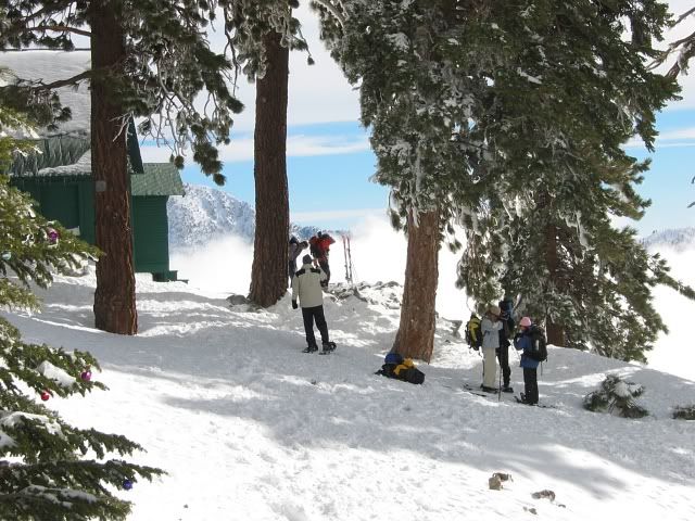
I got started at 6:30 and almost immediately ran into Cheryl at the trail register just above the road. I met her the last time I was on Baldy, in June. I seem to meet someone I know every time I go up there. We agreed that while we don't mind hiking with other people, we usually prefer arranging solo hikes because it's such a pain in the ass getting people to meet in one place at one time, especially if it is early in the morning. We hiked together to the Ski Hut, arriving just before 8:00.
Someone has been decorating the trees around the Ski Hut and the summit with Christmas ornaments:
Is this traditional? Unless someone comes back before the winter to remove the decorations, they will be blown by winter storms all over the canyons.
Above the Ski Hut I found it hard going along the steep parts of the ridge. I haven't been in the mountains in over a month and I spent the summer drinking too much beer and not getting enough conditioning hikes in. I was really out of shape. In June I skipped up the trail like a bunny, but this time I staggered along slowly and had to stop every few paces. I decided I'll have to come back for another hike this next weekend.
It was supposed to be a high of 50 degrees, so I wore a wool shirt, which proved to be a bit warm for the hike up, but was welcome later when the wind kicked up on the Devil's Backbone Trail. There was a strange high cloudy haze in the sky that wasn't so nice for photography, but was more pleasant for hiking than direct sunlight. It was a good day for a hike.
I remembered a few weeks ago Dudley reported on the USMC Hellcats crash site a thousand feet below the summit. Patrick was wondering where it was and several people provided directions and maps. So I had some idea of where the crash site was when I sat down for a rest high on the summit ridge. I looked downslope from the trail and pretty soon I could see pieces of wreckage:
So the crash site is clearly visible from the trail itself. Anyone who wants to find it just needs to stop at the trail sign and then turn and look downslope a little to the right.
Cheryl had left the Ski Hut before me and was on the summit long before I got there. As I came near the top, she appeared and said she saw six bighorn sheep heading from the summit over to West Baldy. I headed up and looked over and sure enough most of them re-appeared, though they were moving away from us:
Now in 30 years of hiking in Southern California mountains, I have never before seen a bighorn. When I was younger they were said to be extremely rare and shy, and it was a very lucky person indeed who ever got to see one.
These days, however, I am hearing about bighorn sightings almost weekly. I think either the sheep population has gotten much larger, or the animals are much less shy, as sheep sightings don't seem to be at all rare these days.
So this was my first encounter with bighorns in the wild.
I got to the top about 9:45 and gobbled down my breakfast of crackers, hummus and salami so fast I felt a little ill afterward. But I was ravenous, and really tired, completely out of shape. Cheryl left the summit as I arrived, and for a few minutes it was just myself and one other guy up there, but soon a few more people appeared. By the time I started down about 10:20 there were about half a dozen folks on the top.
There was very little wind at the top. Most of us were a bit chilled from the sweat of the ascent, but it didn't really get cold until I started down the Devil's Backbone trail.
I haven't been down the Devil's Backbone Trail in about ten years or so, and don't remember much from the last trip. For 30 years John Robinson has been calling it the quickest and easiest way to the top (assuming you take the chairlift). This seems to be terrible advice. Compared to the Baldy Bowl Trail (which I hate hiking down, which was why I was trying to find an alternative descent), the Devil's Backbone is steep, unstable and treacherous, if shorter, though it is very scenic. I had to move very slowly down the steeper parts of the trail, and slipped once on the loose gravel.
Of course, I met quite a few people coming up the trail as I descended, most of them, no doubt, with copies of Trails of the Angeles in their packs.
There is quite a bit of interesting scenery around Mt Hardwood, including a sheltered camping spot where Fritz and Taco stayed last year and a web of game trails on the north face of the mountain:
The trail itself is interesting to look at, as it negotiates the jagged knife edge of rocky ridges:
I started seeing a lot of footings and stumps of steel posts that have obviously been cut away at some point in the past. Was there ever a chain installed along the Backbone? What were those steel posts for?
My feet hurt rather badly by the time I was halfway to the chair lift, partly because I had forgotten to trim my large toenails, so I made very slow progress down. I couldn't believe how steep some of the slopes were, on this, Robinson's "easiest way to the top." I still much prefer the Baldy Bowl Trail. I was grateful to be able to buy a Coke in the upper lift lodge, as for some reason I was craving a sweet drink, which I normally don't care for.
Except for my aching feet, I felt pretty good as I approached my car near the start of the San Antonio Falls road, at about 1:30. I need to get a few more high elevation hikes in before the winter gets here.
Moar photos.
Just another Baldy loop hike, 22 Nov 2008
-
FIGHT ON
Nice hike report and pics.
The first time I started looking to hike to the top was about 1.5 years ago and used the map from the 1990 Robinson Book. (it doesn't even show the
Ski Hut Trail in it going past the hut.) I have still only been on three routes up, Manker, Backbone and Bear flats trails. And as steep as the Ski Hut Trail is past the hut I still think the Bear Flat Trail is the hardest. BTW, Have you done that hike yet?
It is! Only four miles or so from the top of the chairs. There sure is a lot less elevation gain than from Manker Flats! It's a little steep just before you get to the top but my experience is if you stay to the forks on the right on the way up and to the left on the way down it's not so unstable. But don't you think going up the trail past that bolder field up to the ridge is as hard? That's steep!simonov wrote: Robinson's "easiest way to the top."
The first time I started looking to hike to the top was about 1.5 years ago and used the map from the 1990 Robinson Book. (it doesn't even show the
Ski Hut Trail in it going past the hut.) I have still only been on three routes up, Manker, Backbone and Bear flats trails. And as steep as the Ski Hut Trail is past the hut I still think the Bear Flat Trail is the hardest. BTW, Have you done that hike yet?
-
Tim

- Posts: 560
- Joined: Tue Apr 08, 2008 8:55 pm
Nice TR! I think the Christmas decorations are traditional. Here's a picture from 2005. You can see the globe ornaments on the Christmas tree to the left.
I also prefer the Ski Hut trail over the DBB, going up or going down. Going down the DBB seems to take forever and that last section before Baldy Notch is hella steep. I'm also too cheap to pay for the ski lift going up or going down. Although in the winter, the DBB route is kinda fun (except for the crux at the mini bowl) because you get to walk down the ski slopes in your mountaineering gear and get funny looks
I also prefer the Ski Hut trail over the DBB, going up or going down. Going down the DBB seems to take forever and that last section before Baldy Notch is hella steep. I'm also too cheap to pay for the ski lift going up or going down. Although in the winter, the DBB route is kinda fun (except for the crux at the mini bowl) because you get to walk down the ski slopes in your mountaineering gear and get funny looks
-
RichardK

- Posts: 727
- Joined: Sun Sep 30, 2007 12:33 pm
I read somewhere that there used to be safety cables at the beginning of the Backbone trail. I think they were removed because they detracted from the wilderness aspect of the area.I started seeing a lot of footings and stumps of steel posts that have obviously been cut away at some point in the past. Was there ever a chain installed along the Backbone? What were those steel posts for?
I don't like the long downhill of the Ski Hut trail - it's just too hard on my knees. The Backbone trail combined with the chair lift knocks a few miles off the descent.
-
Taco

- Snownado survivor
- Posts: 6136
- Joined: Thu Sep 27, 2007 4:35 pm
Nice shots! Good filter (right?), yer new piece of camera gear. Looks nice!
For descent, typically in winter, I like to go down DBB from the summit, but veer sort-of into the bowl, basically heading down just west of the saddle between Baldy and Harwood. Typically, I just do a standing glissade down to the Ski Hut, and take the Ski Hut trail to my vehicle.
For descent, typically in winter, I like to go down DBB from the summit, but veer sort-of into the bowl, basically heading down just west of the saddle between Baldy and Harwood. Typically, I just do a standing glissade down to the Ski Hut, and take the Ski Hut trail to my vehicle.
-
bertfivesix
- Posts: 206
- Joined: Wed Dec 19, 2007 3:29 pm
+1 for standing glissades down the Bowl.
whee!
whee!
-
simonov

- Posts: 1102
- Joined: Tue Nov 27, 2007 5:44 pm
- Location: Reno, NV
I strongly recommend a polarizing filter for mountain photography. I got the idea after seeing one of Tim's trip reports about a climb up Cucamonga, and he mentioned he was using a polarizing filter for the photos. The filter makes the skies bluer and also bumps up the color saturation in certain situations, while at the same time desaturating some images in an interesting way. And because it cuts through haze, it usually provides clearer, sharper landscapes.TacoDelRio wrote:Nice shots! Good filter (right?), yer new piece of camera gear. Looks nice!
I haven't been up Bear Flat yet. Thank goodness I didn't try this last weekend, I would have died. Definitely not in shape yet. Depending on how much snow we get this week I'll trying it in the next few weeks, after a few more training hikes. I have an open offer to climb Saddleback this weekend, that's a good conditioning hike.FIGHT ON wrote:I have still only been on three routes up, Manker, Backbone and Bear flats trails. And as steep as the Ski Hut Trail is past the hut I still think the Bear Flat Trail is the hardest. BTW, Have you done that hike yet?
By the way, as I was driving home though the Village I saw my dog's brother's head poking out the rear window of a parked car, the same dog I saw on the Ski Hut Trail in March:
I turned the car around and went up and had a chat with the owners. Apparently they bring Grizzly up to the mountains pretty often. If I hadn't planned to use the chair lift, I would have brought my dog on Saturday too.
Nunc est bibendum
-
FIGHT ON
They look clear, that's for sure. I wanna get one. I wished you had taken 2 shots of one scene, 1 with and 1 without the filter. I really wanna see what the difference is. Maybe you can on your next hike or what ever. Would be very interesting.simonov wrote:
I strongly recommend a polarizing filter for mountain photography. I got the idea after seeing one of Tim's trip reports about a climb up Cucamonga, and he mentioned he was using a polarizing filter for the photos. The filter makes the skies bluer and also bumps up the color saturation in certain situations, while at the same time desaturating some images in an interesting way. And because it cuts through haze, it usually provides clearer, sharper landscapes.
Is the filter easy to remove and install?
What do they do just screw on over the lens? Or do you have to take the whole camera apart?
Wow! Haven't done it yet! GREAT!simonov wrote: I haven't been up Bear Flat yet. Thank goodness I didn't try this last weekend, I would have died. Definitely not in shape yet. Depending on how much snow we get this week I'll trying it in the next few weeks, after a few more training hikes.
I DON'T WANNA
 BUT JUST FOR THE FIRST TIME, JUST ONCE, START WAY BEFORE THE SUN COMES UP. AND ABOVE ALL, THE MOST IMPORTANT THING IS TO......... GO ALONE!!!
-
Tim
- Posts: 560
- Joined: Tue Apr 08, 2008 8:55 pm
I like descending this way too in the winter. I think there's less of chance of rockfall on that side of the bowl. I'll go up the center of the bowl but I don't like going down the center.TacoDelRio wrote:For descent, typically in winter, I like to go down DBB from the summit, but veer sort-of into the bowl, basically heading down just west of the saddle between Baldy and Harwood. Typically, I just do a standing glissade down to the Ski Hut, and take the Ski Hut trail to my vehicle.
+2 on the standing glissade!
Polarizers are great! Although I think I might have been misunderstood. I use a Canon P&S camera while hiking so I've never used a polarizer. This is only because I can't mount one to my camera. If I was doing more serious photography I'd bring an SLR, tripod, and polarizing and ND filters.simonov wrote:I got the idea after seeing one of Tim's trip reports about a climb up Cucamonga, and he mentioned he was using a polarizing filter for the photos.
Like simonov said, polarizer are great for outdoor photography because they punch up the colors, darken skies, increase contrast and remove glare and reflections from glass and water. They work best during the middle of the day when the sun is strongest and the effect is most pronounced when 90 degrees to the sun. That means that the subject that you are shooting will display maximum polarization at right angles to the sun's position. With the sun right behind you (180 degrees), polarization is almost non-existent.
Here's a great example of a polarizer at work:

Another filter that outdoor photographers use a lot is a graduated neutral density (ND) filter. This helps even out the exposure if one part of the frame, for example the sky, is too bright.
Marc Adamus is a genius at landscape photography. Check out his gallery below. You can click on the details tab for each picture to see what filters, if any, he uses for each shot. Most of his photos are during the early morning or late afternoon so he uses an ND filter more often than a polarizer. Although filters are good tools, the hardest thing about landscape photography is being at the right place at the right time when the light and skies are just right. It usually means getting up really early and/or staying really late and traveling deep into remote areas.
http://photo.net/photodb/member-photos?user_id=1353935
http://www.marcadamus.com/
-
FIGHT ON
Wow!
This is an amazing picture!
I'm dying to see what this same picture would look like w/o filters.
Do you have any examples of that?
This is an amazing picture!
So worth it! Look at that picture!!Tim wrote:It usually means getting up really early and/or staying really late and traveling deep into remote areas.
I'm dying to see what this same picture would look like w/o filters.
Do you have any examples of that?
