
Search found 722 matches
- Sun Jul 27, 2008 9:52 am
- Forum: San Gabriels
- Topic: Mt. Baldy 2008-07-26
- Replies: 9
- Views: 159
Re: Mt. Baldy 2008-07-26
Lots of clouds, but nothing got close to a real thunderhead.
- Sun Jul 27, 2008 8:08 am
- Forum: San Gabriels
- Topic: Mt. Baldy 2008-07-26
- Replies: 9
- Views: 159
Mt. Baldy 2008-07-26
We hiked Baldy up the Ski Hut trail and down the Devil's Backbone yesterday. We passed 6 or 8 two person crews each carrying roofing panels to the Ski Hut. The plywood is now covered with something black (tar paper?). It was unusually humid, but that made for a lot of clouds. Here is picture of Mt. ...
- Tue Jul 22, 2008 8:20 am
- Forum: San Gabriels
- Topic: Ontario Peak - 20 July 2008
- Replies: 6
- Views: 126
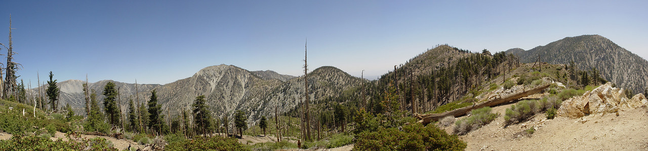
Re: Ontario Peak - 20 July 2008
I understand that the dead trees are from a fire maybe 20 years ago. I don't know the exact date, but someone here probably does. It shows how long it takes the forest to recover when old growth trees burn. I agree that the landscape is surreal. Nice report!
- Mon Jul 21, 2008 10:10 pm
- Forum: Admin & Tech Support
- Topic: Forum Logo (Header/Banner Picture)
- Replies: 299
- Views: 16046
Re: Forum Logo (Header/Banner Picture)
Go a little wider on that shot and you get Bighorn, Etiwanda, and Cucamonga.
- Mon Jul 21, 2008 10:04 pm
- Forum: Admin & Tech Support
- Topic: Forum Logo (Header/Banner Picture)
- Replies: 299
- Views: 16046
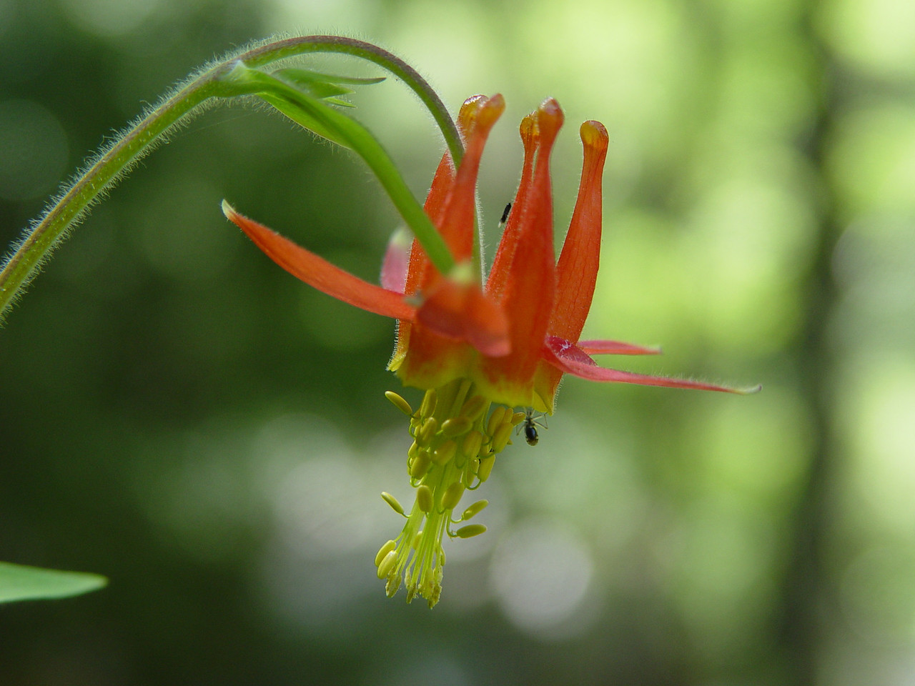
Re: Forum Logo (Header/Banner Picture)
If they don't have to be landscapes, here is an Icehouse Canyon columbine.
- Mon Jul 21, 2008 9:59 pm
- Forum: San Gabriels
- Topic: Telegraph Peak 2008-07-19
- Replies: 3
- Views: 82
Telegraph Peak 2008-07-19
We hiked Telegraph via Icehouse Canyon on Saturday. Round trip is 12.2 miles with about 4625 feet of elevation gain. I estimated from Topo! maps that the Timber-Telegraph saddle adds around 300 feet each way to the altitude difference. Here is Baldy from Telegraph's summit. https://eispiraten.com/im...
- Thu Jul 10, 2008 11:57 am
- Forum: Gear & Fitness
- Topic: Bug Repellant
- Replies: 2
- Views: 112
Re: Bug Repellant
The bugs have been a nuisance in Icehouse for the last few weeks. I just walk fast and pray for a breeze to blow them away. Bug nets work, but they are hot and interfere with vision. I have never tried Deet or anything like that.
- Wed Jul 09, 2008 8:17 am
- Forum: San Gabriels
- Topic: Ontario Peak 7/7/2008
- Replies: 16
- Views: 278
Re: Ontario Peak 7/7/2008
Hikin_Jim - Thanks for the correction. It is WEST!
- Tue Jul 08, 2008 9:20 pm
- Forum: San Gabriels
- Topic: Ontario Peak 7/7/2008
- Replies: 16
- Views: 278
Re: Ontario Peak 7/7/2008
Hikin_Jim - Nice trip report. I'm glad to learn that the springs are drinkable. Funyan005 - Walk west across the camp away from the trail. Look for a grassy area. One of the springs is there. Near the top of Cucamonga, you get a nice view of the Ontario ridgeline with all the false summits. https://...
- Sun Jul 06, 2008 7:20 am
- Forum: San Gabriels
- Topic: Cucamonga Peak Sunset, 04-July-2008
- Replies: 17
- Views: 261
Re: Cucamonga Peak Sunset, 04-July-2008
My wife and I must have passed you on the trail. We dayhiked Cucamonga on the Fourth. We were on the trail from 8AM to 5PM. We saw nobody on the way up, but passed about a dozen backpackers on the way down. Nice report. Here is a pano looking east. https://eispiraten.com/images-archived/richardk.smu...
- Tue Jun 24, 2008 7:59 am
- Forum: San Gabriels
- Topic: Kelly Camp Spring
- Replies: 10
- Views: 175
Re: Kelly Camp Spring
We have been drinking from Columbine for years without any bad effect. The water there comes directly out of granite. However, the pipe does not look very inviting and, by refilling at Columbine going up and coming down, we didn't need the water anyway. If I were going to drink from the pipe, I thin...
- Mon Jun 23, 2008 9:03 pm
- Forum: San Gabriels
- Topic: Kelly Camp Spring
- Replies: 10
- Views: 175
Re: Kelly Camp Spring
Hi Jim, I think you got points A and B reversed on your map. The picture was taken at the map's point B maybe 200 or 300 feet west of the bend in the trail at Kelly's. If you walk across the camp westerly away from the trail, you will see a grassy area. A faint use trail leads to the pipe. I have no...
- Mon Jun 23, 2008 8:14 am
- Forum: General Discussion
- Topic: Help get rid of the Adventure Pass!
- Replies: 50
- Views: 766
Re: Help get rid of the Adventure Pass!
The $2 billion a week being wasted on the Iraq boondoggle would buy a lot of Adventure Passes.
- Sun Jun 22, 2008 11:54 am
- Forum: San Gabriels
- Topic: Kelly Camp Spring
- Replies: 10
- Views: 175
Kelly Camp Spring
We hiked Ontario yesterday. The heat was not bad until 1:00PM, but we were on the descent by then. We could see the SAR copter orbiting the Ski Hut. The Kelly Camp Spring was flowing, but low. Here is a picture: https://eispiraten.com/images-archived/richardk.smugmug.com/photos/317680206_pysEN-XL.jpg
- Tue Jun 17, 2008 1:52 pm
- Forum: San Gabriels
- Topic: mt baldy summit [1st time]
- Replies: 14
- Views: 230
Re: mt baldy summit [1st time]
Congrats on making the summit!! You are right. The Ski Hut trail downhill is rough on the knees. We always hike down the backbone. Take $8 for the ski lift and ride it down to the parking lot.next time im going down the backbone..going down the ski hut trail
was harder than going up.
- Sun Jun 15, 2008 12:31 pm
- Forum: San Gabriels
- Topic: Bear Flat burn area
- Replies: 5
- Views: 121
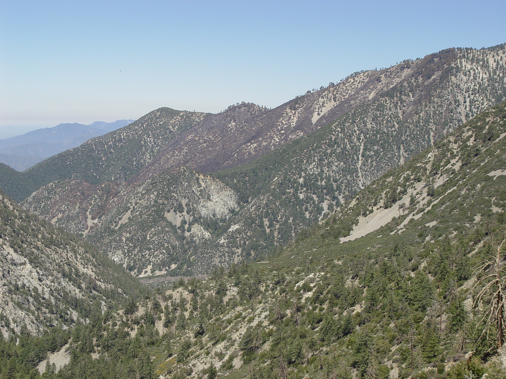
Bear Flat burn area
We hiked Icehouse Canyon via the Chapman Trail Saturday. You can see part of the burn area from the Bear Flat fire.
- Wed May 21, 2008 8:54 pm
- Forum: General Discussion
- Topic: San Sevaine - Cucamonga - Stone House crossing
- Replies: 4
- Views: 137
Re: San Sevaine - Cucamonga - Stone House crossing
I found a couple of 10 year old trip reports at this link:
http://tchester.org/sgm/links/100.html
It sounds like you need a 4WD vehicle to get close to the trailhead.
http://tchester.org/sgm/links/100.html
It sounds like you need a 4WD vehicle to get close to the trailhead.
- Fri May 16, 2008 9:07 pm
- Forum: News & Conditions
- Topic: Fire above Baldy Village
- Replies: 30
- Views: 588
Re: Fire above Baldy Village
Mt. Baldy ski lifts sent out this message: Hot. Hot. Hot. It's really cooking at Baldy! For those of you who have not heard about the fires going on in Baldy. Rest assured we are all fine. No structures were lost.Thanks to those wonderful firefighters.There are only a few smoldering fires & they...
- Sun Apr 20, 2008 5:24 pm
- Forum: Admin & Tech Support
- Topic: Travis Leaving California
- Replies: 12
- Views: 275
Re: Travis Leaving California
Many thanks to Travis for this board. Best Wishes for the future!
- Sun Mar 09, 2008 11:18 am
- Forum: Gear & Fitness
- Topic: GPS device suggestions
- Replies: 10
- Views: 261
Re: GPS device suggestions
Here is a good discussion about GPS altitude accuracy:
http://gpsinformation.net/main/altitude.htm
I think that the altitude accuracy of GPS receivers is inherent in the system. Altitude accuracy is going to be 1.5 times horizontal no matter which receiver you use.
http://gpsinformation.net/main/altitude.htm
I think that the altitude accuracy of GPS receivers is inherent in the system. Altitude accuracy is going to be 1.5 times horizontal no matter which receiver you use.
- Tue Jan 08, 2008 7:16 pm
- Forum: San Gabriels
- Topic: 20080108 Icehouse Canyon
- Replies: 14
- Views: 281
Re: 20080108 Icehouse Canyon
The Icehouse Canyon outhouse was tagged back in the summer, although only the eastside. The Forest Service (or somebody) painted over it very quickly.
- Sat Nov 03, 2007 5:50 pm
- Forum: News & Conditions
- Topic: Angeles National Forest to Remain Closed this Weekend
- Replies: 12
- Views: 295
Re: Angeles National Forest to Remain Closed this Weekend
I guess Crystal Cove was spooked by the Santa Ana winds forecast which never seemed to materialize. We pulled up to the park entrance to find it gated shut. Fortunately, Laguna Coast Wilderness Park was open.
- Thu Nov 01, 2007 2:27 pm
- Forum: News & Conditions
- Topic: Angeles National Forest to Remain Closed this Weekend
- Replies: 12
- Views: 295
Re: Angeles National Forest to Remain Closed this Weekend
I spoke with the ranger's office at Crystal Cove State Park in Laguna Beach. They have reopened. We do an 8 mile loop around the park perimeter. Note that is does cost $10 to park.
- Tue Oct 30, 2007 10:40 am
- Forum: Admin & Tech Support
- Topic: Trolls
- Replies: 12
- Views: 285
Re: Trolls
Thanks for your efforts!! Now, if it would only rain, we could actually hike the San Gabriels.
- Sat Oct 27, 2007 9:31 am
- Forum: News & Conditions
- Topic: Angeles National Forest Closure - October 23
- Replies: 69
- Views: 1672
Re: Angeles National Forest Closure - October 23
Betty Goat is an obvious troll.
- Wed Oct 24, 2007 4:21 pm
- Forum: News & Conditions
- Topic: Angeles National Forest Closure - October 23
- Replies: 69
- Views: 1672
Re: Angeles National Forest Closure - October 23
Chino Hills State Park is closed.
Crystal Cove State Park is closed.
Laguna Coast Wilderness Park is closed.
Riley Wilderness Park is closed.
It looks like a weekend hiking the stair master.
Crystal Cove State Park is closed.
Laguna Coast Wilderness Park is closed.
Riley Wilderness Park is closed.
It looks like a weekend hiking the stair master.
- Sun Oct 21, 2007 7:56 am
- Forum: Admin & Tech Support
- Topic: A message from your friendly local moderator
- Replies: 2
- Views: 85
Re: A message from your friendly local moderator
Trolls have been a problem on hiking message boards starting several years ago with the Mt. Whitney board. It got so bad there that the board shut down for several months. The moderators have no choice but constant vigilance. They must read every post every day and delete messages and accounts at th...
- Mon Oct 15, 2007 8:32 am
- Forum: General Discussion
- Topic: BALDY - Archive of Mt. Baldy-related Discussions
- Replies: 430
- Views: 17191
Re: BALDY - Archive of Mt. Baldy-related Discussions
I have been told by the Visitor Center rangers that they like to open at 7AM in the summer to accomodate the early hikers. In winter, they go to the 8AM opening time. Closing is at 3:30 summer and 4:30 winter. The main thing is, if you park a vehicle inside their gate, be sure to know the closing ti...
- Wed Oct 10, 2007 10:19 am
- Forum: General Discussion
- Topic: Cucamonga Question
- Replies: 5
- Views: 158
Re: Cucamonga Question
I have never seen a register or benchmark on Cucamonga either. We were up there last in August.
- Mon Oct 01, 2007 1:03 pm
- Forum: San Gabriels
- Topic: Chapman Trail
- Replies: 8
- Views: 226
Re: Chapman Trail
Cedar Glen is a beautiful spot. It is primitive camping - no facilities. If you wanted to access the ridge to Thunder, my recollection is that you would be doing some bushwacking and boulder scrambling. burtw posted this account on the Mt. Whitney board last May: Another interesting route in the Ice...