
Search found 1137 matches
- Thu Dec 18, 2008 6:42 am
- Forum: Gear & Fitness
- Topic: GPS Discussion #2 Elevation Gain
- Replies: 8
- Views: 176
Re: GPS Discussion #2 Elevation Gain
Well it seems to me.... The device parameters need to be established. If you are using the GPS elevation. There can be large errors, if you have a poor fix. in the case of the Garmin "S" models the elevation is a barometric elevation. I "feel" this is more accurate than the topog...
- Wed Dec 17, 2008 7:25 am
- Forum: News & Conditions
- Topic: Report: Arson Investigator Started SoCal Fires
- Replies: 9
- Views: 216
Report: Arson Investigator Started SoCal Fires
This was a poll. These haven't been imported. Sorry.
- Tue Dec 16, 2008 9:39 am
- Forum: Gear & Fitness
- Topic: i need chains
- Replies: 19
- Views: 325
Re: i need chains
I'm pretty sure studded tires are illegal in California. From the CHP website http://www.chp.ca.gov/html/answers.html I have studded tires installed on my vehicle. Are they legal in California? When? The California Vehicle Code Section 27454 (e), permits studded tires to be used on vehicles between...
- Tue Dec 16, 2008 5:15 am
- Forum: Gear & Fitness
- Topic: i need chains
- Replies: 19
- Views: 325
Re: i need chains
When I lived in New England, I kept the chains on 2 spare tires in my trunk. I slightly deflated the tire then put the chains on tight then reinflated the tire. This kept the chains on tight had I only had to change 2 tires when I needed my chains. You might want to try studded snow tires, don't kno...
- Thu Dec 04, 2008 5:38 pm
- Forum: News & Conditions
- Topic: Old Mt. Wilson Trail
- Replies: 51
- Views: 3481
Re: Old Mt. Wilson Trail
From the City of Sierra Madre "The Mt. Wilson Trail will be open on weekdays due to a change in the work schedule of the California Conservation Corps. The Mt. Wilson Trail will be subject to intermittent closures Monday through Thursday for the next two months. Please use alternate trials out ...
- Wed Dec 03, 2008 6:27 am
- Forum: News & Conditions
- Topic: Old Mt. Wilson Trail
- Replies: 51
- Views: 3481
Old Mt. Wilson Trail
This is a message I got from the City of Sierra Madre Plan accordingly.... Matt "The Skyland Slope Restoration Project will be starting today, December 2, 2008 on the Mt. Wilson Trail. The restoration project will be headed by the California Conservation Corps with the help of the Sierra Madre ...
- Mon Dec 01, 2008 11:18 am
- Forum: San Gabriels
- Topic: (yawn) Yet another Baldy climb, 30 Nov 2008
- Replies: 4
- Views: 68
Re: (yawn) Yet another Baldy climb, 30 Nov 2008
This would be my guess
http://www.dankat.com/advents/santcr.htm
A group went down there on Saturday so the tracks would have been nice and fresh
Matt
http://www.dankat.com/advents/santcr.htm
A group went down there on Saturday so the tracks would have been nice and fresh
Matt
- Tue Nov 25, 2008 6:22 am
- Forum: San Gabriels
- Topic: TR: BRUIN HIGHWAY 2008/11/23
- Replies: 1
- Views: 39
TR: BRUIN HIGHWAY 2008/11/23
TR: BRUIN HIGHWAY 2008/11/23 * ACA Rating: 3AIII * Our hiking time: 6½ hours * Our Hiking distance: 6.7 miles(est) * Elevation loss: 2880 * Elevation gain: 2280 * Required equipment: Standard canyoneering gear 150ft rope, 150ft pull cord, 100ft webbing 6 quicklinks * Rappels: 6-7 120ft largest Acme...
- Wed Nov 19, 2008 5:54 pm
- Forum: General Discussion
- Topic: Josephine, Strawberry, & Lawlor Loop
- Replies: 10
- Views: 151
Re: Josephine, Strawberry, & Lawlor Loop
Matt, do you have gps coords or marked up map showing your route from AFH to the main west ridge? Well by "some years ago" I'm talking 20+ years GPS wasn't of much use then with SA enabled.... I wasn't leading...didn't plan the trip... But I'll give it a go.... We parked on AFH went acros...
- Wed Nov 19, 2008 3:30 pm
- Forum: Flora, Fauna & Fungi
- Topic: Snake with a problem.....
- Replies: 2
- Views: 71
- Wed Nov 19, 2008 3:08 pm
- Forum: Flora, Fauna & Fungi
- Topic: Snake with a problem.....
- Replies: 2
- Views: 71

- Wed Nov 19, 2008 2:56 pm
- Forum: General Discussion
- Topic: Josephine, Strawberry, & Lawlor Loop
- Replies: 10
- Views: 151
Re: Josephine, Strawberry, & Lawlor Loop
My recommendation would be to take the road to the summit, take the ridge down. Turn off the ridge before it drops off The map shows my route on 1/30/2005 One alternate would be to come up from AFH from mile marker 22.95 XC to Josephine. I did this some years ago on an HPS trip. The Sierra Club may ...
- Tue Nov 18, 2008 7:36 am
- Forum: San Gabriels
- Topic: TR: Camp Five Canyon 11/15/2008
- Replies: 5
- Views: 92
Re: TR: Camp Five Canyon 11/15/2008
Guess I forgot the photos....Hikin_Jim wrote:Cool stuff. Very thorough TR.
http://picasaweb.google.com/mattmaxon91040/2008_11_15#
- Sun Nov 16, 2008 6:22 pm
- Forum: San Gabriels
- Topic: TR: Camp Five Canyon 11/15/2008
- Replies: 5
- Views: 92
TR: Camp Five Canyon 11/15/2008
TR: Camp Five Canyon 11/15/2008 * ACA Rating: 3BII * Our hiking time: 4 hours * Our Hiking distance: 3.5 miles(est) * Elevation loss: 1370ft * Elevation gain: 1140ft * Required equipment: Standard canyoneering gear 150ft rope, 150ft pull cord, 100ft webbing 4 quicklinks * Rappels: 2-4 largest 150ft...
- Sat Nov 15, 2008 5:58 pm
- Forum: San Gabriels
- Topic: Vincent Gap to Bighorn Mine to Prairie fork and back 11/14/08
- Replies: 27
- Views: 448
Re: Vincent Gap to Bighorn Mine to Prairie fork and back 11/14/08
After reaching Praire fork I made the left turn at Vincent Gulch, and was searching for the Vincent trail when I stumbled upon an old plane wreck. Anyone know the history of this one? Looks like an old Cessna or something./ Did you get any other photos... GPS data etc? Part numbers registration num...
- Fri Nov 14, 2008 4:19 pm
- Forum: News & Conditions
- Topic: Ken Burton Trail
- Replies: 35
- Views: 838
Re: Ken Burton Trail
The last time I was out on the Ken Burton Trail was 3/24/2005, it was in decent shape then. Like Jim sez the map for once is accurate! How'd that happen? The Dark Canyon Trail is an old road grade, and while there are slides from 2005 deluge I personally wouldn't consider it impassable. The segment ...
- Wed Nov 12, 2008 5:12 am
- Forum: San Gabriels
- Topic: Mt Williamson & Pleasant View Ridge
- Replies: 23
- Views: 263
Re: Mt Williamson & Pleasant View Ridge
That being said I did my best to figure out the Mapping Software with Overlays but must be doing it wrong. Those of you who use that software all the time, can you give me a run down on how to do it right? Well using the default settings on the KML overlay just enter your zipcode in the Location bo...
- Tue Nov 11, 2008 1:36 pm
- Forum: San Gabriels
- Topic: Mt Williamson & Pleasant View Ridge
- Replies: 23
- Views: 263
Re: Mt Williamson & Pleasant View Ridge
Neat old map. Shows all the cabins (houses?) up in Haines Canyon that are just ruins now. I believe that area was known as "Azteca", why it was on the 1939 topo when it was washed away in 1938 is a mystery to me... So few streets in La Crescenta back in the day, but the general layout of ...
- Tue Nov 11, 2008 10:29 am
- Forum: San Gabriels
- Topic: Mt Williamson & Pleasant View Ridge
- Replies: 23
- Views: 263
Re: Mt Williamson & Pleasant View Ridge
What type of file is a .sid file? I'm not familiar with that type of file. http://en.wikipedia.org/wiki/MrSID Expressview Plugin for windows I love old maps. I've got a lot of my dad's old 15' War Dept. maps from the 40's and 50's for the Sierra and also local maps. Pretty cool stuff. I probably sh...
- Tue Nov 11, 2008 9:55 am
- Forum: San Gabriels
- Topic: Mt Williamson & Pleasant View Ridge
- Replies: 23
- Views: 263
Re: Mt Williamson & Pleasant View Ridge
Nice! 1939 6' x 6'? Where do you get these maps? http://cricket.csuchico.edu/spcfotos/ma ... earch.html Once upon a time you where able to download the entire file which I did... La Cresenta 1939 6x6 USGS topo One map I have only briefly seen and would like to study in more detail is the 30x15 1900...
- Tue Nov 11, 2008 6:15 am
- Forum: San Gabriels
- Topic: Mt Williamson & Pleasant View Ridge
- Replies: 23
- Views: 263
Re: Mt Williamson & Pleasant View Ridge
Generate google earth overlays here... http://www.gpsvisualizer.com/kml_overlay One very interesting effect is to adjust the transparency of the overlay.... Nice... The only program that I found that did that was Topofusion Stone Canyon Trail (the white track is the Stone Cyn trail as shown on the ...
- Mon Nov 10, 2008 6:47 am
- Forum: San Gabriels
- Topic: Mt Williamson & Pleasant View Ridge
- Replies: 23
- Views: 263
Re: Mt Williamson & Pleasant View Ridge
I am interested in how the topo map overlay was done...
Would you care to share?
Was it a simple image overlay? or some other method
Thanks
Matt
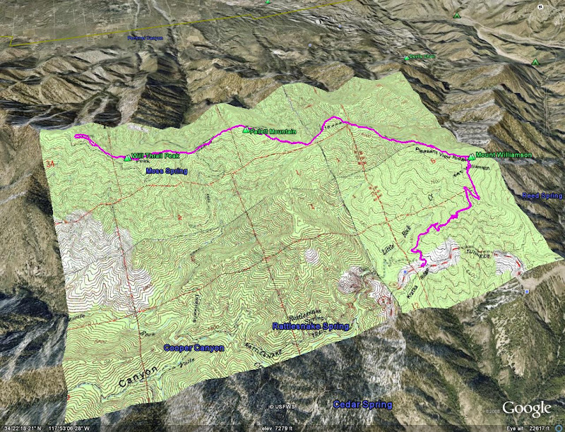
Would you care to share?
Was it a simple image overlay? or some other method
Thanks
Matt
- Fri Nov 07, 2008 8:51 am
- Forum: News & Conditions
- Topic: Pleasant View Ridge and Mt. Williamson
- Replies: 19
- Views: 439
Re: Pleasant View Ridge and Mt. Williamson
There is a large flat area on the north side of the road

- Wed Nov 05, 2008 10:20 am
- Forum: News & Conditions
- Topic: Pleasant View Ridge and Mt. Williamson
- Replies: 19
- Views: 439
Re: Pleasant View Ridge and Mt. Williamson
I hiked from Williamson twice in the last 12 months to "Boxcar Ridge" and encountered no problems, not that I'd expect to... As to an alternate route.... Hike up to Buckhorn & ACH, then the Waterman Mtn Trail (mile marker 58.15) to Kratka Ridge. Kratka Ridge is similar to Pleasant View...
- Tue Nov 04, 2008 4:20 pm
- Forum: News & Conditions
- Topic: Angeles Crest Highway (CA-2)
- Replies: 639
- Views: 18027
Re: Angeles Crest Highway (CA-2)
Wrightwood web camsRumpled wrote:Is it snowing up there? It rained down here.
Big Pines RAWS
Wundermap
Mtn High web cams
- Tue Nov 04, 2008 3:55 pm
- Forum: San Gabriels
- Topic: Inspiration Point & Muir Peak via the Great Incline
- Replies: 21
- Views: 244
Re: Inspiration Point & Muir Peak via the Great Incline
Interesting. I wonder if CCD is why there are no longer bees in Haines Canyon. There were quite a number of hive boxes near the water tank above the bend in 2N76 until about a year or two ago. Now, even the fence posts have been removed. That is what I surmise. These where scattered through out the...
- Tue Nov 04, 2008 1:51 pm
- Forum: San Gabriels
- Topic: Inspiration Point & Muir Peak via the Great Incline
- Replies: 21
- Views: 244
Re: Inspiration Point & Muir Peak via the Great Incline
This looks to me like two beehives in a stronger enclosure. Keep bears out maybe? Severe weather protection? My guess would be to keep out Bears, darn things are about as common as flys in the Angeles.... Now, why would you put beehives up there? Africanization tracking? Wild honey? Guess I'm just ...
- Mon Nov 03, 2008 1:45 pm
- Forum: Flora, Fauna & Fungi
- Topic: The 'What flower is it (and can you smoke it?)' thread
- Replies: 17
- Views: 336
- Sat Nov 01, 2008 7:18 am
- Forum: News & Conditions
- Topic: Pacifico Mountain Road (3N17)
- Replies: 48
- Views: 1500
- Fri Oct 31, 2008 3:27 pm
- Forum: Flora, Fauna & Fungi
- Topic: question regarding identification of plants
- Replies: 10
- Views: 272
Re: question regarding identification of plants
This has stumped meTravis wrote:I have many field guides on the trees and plants of the San Gabriel Mountains. I enjoy identifying plant, just post the image and I will do my best to identify
Travis
I'm thinking it is a non native
