
Did this 2 weeks ago... ended up being probably the most intensive San Gabriel expedition I've done so far. So far of course
Wanted to take a nice road walk down the mountain and I always like to not have to double back if I can help it, so used 2 cars, with the end point one parked at Oro Vista Ave. Started from the bridge on Little Tujunga Road. I've seen a report of the newly improved Gold Canyon Trail before, and AllTrails said it was in good condition, but we had LOTS of water this time. Big Tujunga Creek was HIGH, even higher than I expected it would be with rain and snowmelt. Turns out that was because out of necessity they were releasing very large amounts of water from Big Tujunga dam. It quickly was apparent we would need to ford the water to continue downstream under the bridge. Got past my knees, which is exciting A) Because I did it barefoot and B) I had a toddler on my back. And THIS was a family adventure
(The trail was completely submerged)
Luckily I instructed my wife to bring her crocs, so we each got one to help with all the shattered granodiorite the San Gabriels supply in abundance that made up the flooded stream bed. Not much help for the other foot, but a trekking pole helped. My son thought it was all quite amusing from his perch.
Once out of the Tujunga we put on our hiking boots and and proceeded up the beautiful gold canyon wash, making out way up freshly cut stream channels and gushing water sparkling in the morning sun. One of the more beautiful hikes I've ever done, through this section. There is something special about gushing winter water in the San Gabriels - so ephemeral, the streams nothing but water and shattered granite. Like someone just turned on a hose for a few hours.
The Backside of Mt Lukens looked like something out of Thailand it was so flush with green.
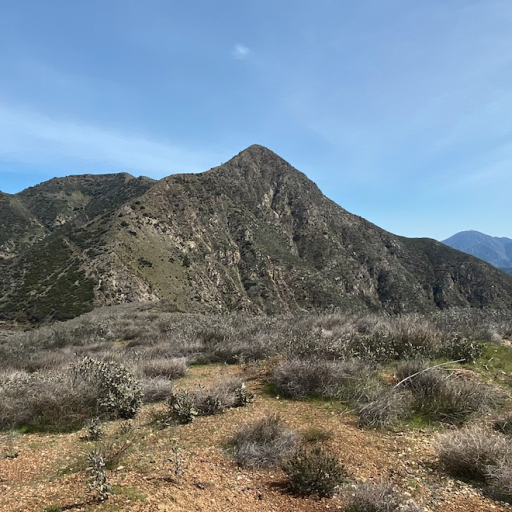
I particularly loved the view up the canyon, where this unnamed peak 3421 rises above the creek, and I felt like I was like fly fishing in Montana or something, not 4 miles from a sprawling megalopolis.
Because of the huge rate of erosion, if the Canyon isn't too steep length-wise you get a depositional environment so the canyon is wide and flat-bottomed, and I'm discovering, great for hiking. Gold Canyon is kind of my first experience with that and I look forward to more "wash" hikes.
The Gold Canyon Trail in its newly refurbished state, is fantastic as I know has been mentioned here. Its held up to the rains pretty well, just a couple landslides here and there. Its a wonderful trail that had a lot of work put into it and applaud the effort to those responsible.
Awesome views of Condor and Medenhall/friends. It will be a special day when I can make it up Condor. Hopefully with my son (NOT on my back though
Yerba Buena is a SPRAWLING mt with an extensive upland area. The road walk to the summit and down again was long long long but great views the whole time. Unfortunately my wife had gotten her feet wet in Gold Creek, so she got some nasty blisters.
Lots of views of peaks I've already climbed, and lots I plan to in the future.
So after long long road hike down, which was lovely if long, we made our way through that private neighborhood that you can only access via Oro Vista Avenue. My original plan was taking the road to bypass said neighborhood to cross the Tujunga to our car, but I now knew the water would be too high to do that safely, certainly with a toddler on my back. So I figured we'd take Oro Vista Ave. We get there, nearly 7pm now, and its block by firetrucks!!! And then suddenly firefighters start coming out of a Yurt tent and surround us. Turns out Oro Vista Ave is impassable with Tujunga Creek being as high as it is cause of the reservoir release, so the ENTIRE NEIGHBORHOOD was cut off from the city, and they sent the Pacoima Fire station to live in a Yurt and basically guard the road from people trying to cross, and be available for emergencies, meanwhile the only way out is the rough Conover Fire Rd which really needs 4WD. So tired and exhausted, my family was cut off from our car at 7pm. But at least we were also in the midst of a team of firefighters with literally nothing to do but play Uno, (Thats literally what they were doing in their Yurt) so things could be worse. We decided my son and wife would hang out with the firefighters playing uno in their yurt, and myself and two of them took their offroad fire truck down Conover Rd and get the car seat out of my car parked at the other end of Oro Vista, and then come back, get my wife and son, and give my son his first real firetruck ride back all the way around to my car again. The firefighters were a huge help here (would have been another maybe 4 mile walk otherwise) and it was definitely a hike for the family history books.
The mountains have never been more beautiful and more dangerous than they are right now - be ready for the unexpected. Water levels on major creeks like Big Tujunga could be higher than you think because of reservoir releases! Be safe. We don't always have a yurt full of firefighters to help us out.
Our GPS route. My wife names all of our hikes we do together, and this one was "Soggy Socks Summit" in honor of her poor feet.
2,796 ft elevation gain
