Rubio canyon

TRs for the San Gabriel Mountains.
Post Reply
User avatar
dima
Posts: 1320
Joined: Wed Feb 12, 2014 1:35 am

Post by dima »

We had a break in the rain yesterday, so Sondra, Wes, Kevin and I went out to Rubio Canyon to check out the waterfalls. It didn't disappoint. This is a loop I really like, and usually end up walking it every year. It tops out at Echo Mountain, which is quite popular, obviously. But both the ascent and descent lines are obscure, so we usually have the place to ourselves. Today we saw two people walking their dogs, 3 canyoneers and Sean.

The new home owner at Camp Huntington Dr has blocked access to the river at the water company reservoir, so we started above, at the old rail right of way at Rubio Vista Dr. The trail is in good shape, and somebody even built a solid wooden bridge over one of the gullies as part of their Eagle Scout project. We took the connector down to the creek (trail is in good shape), and walked the river bed up. The trail comes and goes, since the recent storms are actively reforming the river bottom. There're a few small waterfalls to climb over, but it's pretty easy going. We ran into Sean at the Rubio pavilion ruins. There's a big recent landslide there: a big chunk of the mountain sloughed off into the river from the East. Easy to walk over. The lower falls are working well:

Image

We took some photos, and climbed up the bypass gully

Image

Part of the way up was this water level gauge:

Image

It can measure up to 1000 gallons! Wes was impressed

Image

We didn't bother going to see the middle falls (and Sean said it was impassable, anyway). From the overlook, the Tlalehaha falls are flowing well. And there were even some canyoneers in the process of descending

Image

We kept climbing to a good view of the Leontine falls:

Image

Eventually we found the right trails to connect to the fixed ropes, and dropped down to the area between the two big drops. The less-impressive bottom tier of the Leontine falls:

Image

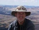
Wes and Sondra climbing up the next section:

Image

Image

Here the river becomes less steep, and it's a nice boulder hop for a while

Image

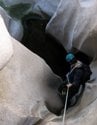
We got to the water intake. The filter is in place, but the pipe it connects to is broken. Wes was not impressed:

Image

Another branch of the water system keeps running up, doing impressive things:

Image

Eventually we decided to begin the climb out. Here you can see the creek further up. It is steeper, and there're more waterfalls:

Image

This part is called "Castle Canyon", I think. In any case, when climbing up, I find the correct line about half the time. If the correct line is not found, some bushwhacking results, and we ended up doing some of that:

Image

We were rewarded with an antler, so it's not all bad. There were a number of hikers up on Echo Mountain, but it wasn't the zoo it often is. We took in the views for a while: clear all the way to Santa Barbara island. And we read the info panels: apparently Thaddeus Lowe was a baloonist, and he once flew 900 miles in 9 hours. Then it was time to descend. I usually take the Incline trail down, but we decided that we have been spending too much time on trails, so we went straight down the old funicular right of way. The top section is off-trail, and I've never done it before. It's very steep, but clear and passable. Looks like this:

Image

Eventually the Incline trail rejoined our line, and it was easy going all the way back down to the trailhead. Loose stats: somewhere between 6-7 miles, 1500-2000ft of gain.
User avatar
maxmapper
Posts: 43
Joined: Fri Jan 17, 2020 5:50 pm

Post by maxmapper »

If anyone has a spare 1.5 million dollars that house that is blocking access will hopefully be listed again for sale soon... let's cross our fingers that the next owner removes all those fences and signs a legal easement for hikers. Interestingly the Camp Huntington access as well as the upper Pleasantridge Dr. trailheads access are are both contingent on verbal agreements with the homeowners, there is no recorded legal access at either site. Many people have looked into legal action due to historical access precedence but all efforts I'm aware of have fallen through. Today the upper entrance is open to the public but this could change at the homeowners whim (such as what happened at the Camp Huntington access point). If you hike from 1101 Loma Alta and go up to the Gooseberry motorway you can enter the canyon on land that has a legal hiking easement (or from Echo Mountain)
User avatar
JeffH
Posts: 1154
Joined: Sun Nov 28, 2010 7:09 am

Post by JeffH »

dima wrote: ... And we read the info panels: apparently Thaddeus Lowe was a baloonist, and he once flew 900 miles in 9 hours.
I have read that he claimed to be the most shot-at man in the Civil War as he used observation balloons to assist the Union army.
"Argue for your limitations and sure enough they're yours".
Donald Shimoda
User avatar
Sean
Posts: 3749
Joined: Wed Jul 27, 2011 12:32 pm

Post by Sean »

You guys picked the right time to see the falls. I'm in Rubio a lot and people are always asking me about the falls but it's usually the wrong time of year when they're dry or trickling. The landslide you mentioned wiped out some trees. At least one huge boulder came down with such force that it snapped trees in half.

20211226_105440-001.jpg

(Meeting the group)

20211226_093531.jpg

(New landslide)

20211226_094317.jpg

(Broken tree trunks)

20211226_094505.jpg

(Broken tree)

20211226_094003.jpg

(I suspect this big rock took out the trees)
User avatar
Girl Hiker
Posts: 1318
Joined: Fri Apr 04, 2014 7:46 am

Post by Girl Hiker »

If you hike from 1101 Loma Alta and go up to the Gooseberry motorway you can enter the canyon on land that has a legal hiking easement (or from Echo Mountain)
Yup! That's the route I always take. I do t like tp publicize it though because I like it the way it is now, without alot of un-necessary riff raff and taggers.
User avatar
AW~
Posts: 2038
Joined: Mon Oct 01, 2007 12:00 pm

Post by AW~ »

Its always been on the brink...especially since it has the most trail per acre. I was a big proponent of access...wanting no major obstacles . But keeping it the same won out handily. I mean its supposed to be a museum route complementing Echo Mtn. Man vs nature. The conservancy changed it up, but still..once it was explained, they were very gracious.

Leontine is what it is....you actually rappel at least twice ...so there is that. It was none...but some people had to visit when its wet :-) not me?.
The cascade...is in Rubio , not Castle...which is a historic water pipe throughout the bottom.

The blocking access is a big sigh. But for everybody. But I have faith it will be restored...because at end of the day its the best design. I dont like it either, the camp huntington access, so its strange arguing for it, but yeah its best. The pleasant ridge one.... Again, theres this big increase in 'mass public' but the design is forever. Give us a chance to be reasonable neighbors...as long as a person can hike. You cant close an area because for X number of years because people were weird. You change it up or whatever..but you dont close. But nice try :-).
User avatar
JakubRZ
Posts: 27
Joined: Sat Jun 11, 2022 4:08 pm

Post by JakubRZ »

Yesterday after the rains subsided, I decided to explore Rubio and Echo. I ended up at Moss Grotto falls, but since the flow wasn't super impressive, I turned around and took the incline trail up to Echo, came down Sam Merrill and took shortcut back to Rubio Pleasantridge trailhead. In general Rubio remains full of all kinds of debris, but no serious breaches or landslides. I did notice someone made a sizable hole in an irrigation pipe prior to the old terminal location LOL. It is a shame how much old/new pipe there is in Rubio....but that's an old subject.

The rough incline trail was what I expected, except for two washed out spots. The top half was overgrown with chaparral, which was super wet after the rain. After a while I was completely soaked, but thankfully I brought a change of shirt and fleece for walk down. Echo summit thermometer read 36 degrees, but that couldn't be right at 4pm. No snow in sight, but the ridges above were fog-covered. I headed down SM, where a few places were washed out pretty good. Took the Rubio shortcut, which also took some damage, but all passable.

Overall a good day, will go back up to Leontine once we get more rain. It always amazes me how quickly these trails dry after the rain. Cheers!
IMG_4120.jpeg

Pleasantridge Trailhead. Didn't see that ladder until now...

IMG_4124.jpeg

Moss Grotto flow

IMG_4131.jpeg

Old signage on incline trail

IMG_4132.jpeg

Great view of Rubio. Has anyone kept going past Leontine drop in?

IMG_4136.jpeg

Leontine flow barely visible...I passed on the overlook trail, sorry

IMG_4137.jpeg

Wet overgrown chaparral heading up to Echo

IMG_4138.jpeg
IMG_4139.jpeg

Don't believe it....

IMG_4142.jpeg


IMG_4144.jpeg

Rubio shortcut washed out
User avatar
Sean
Posts: 3749
Joined: Wed Jul 27, 2011 12:32 pm

Post by Sean »

I've dropped into the east branch from the Lone Tree Trail, but I didn't explore much. The water company has an intake up there.
User avatar
HikeUp
Posts: 3847
Joined: Thu Sep 27, 2007 9:21 pm

Post by HikeUp »

Great TR @JakubRZ thanks!

@AW~ and I went up to West Fuji by continuing up Rubio past the overlooks/drop ins. Then we continued up Lone Tree to Muir Peak. I went to Inspiration Pt. and back down via Castle Cyn, Sam Merrill. AW went into Eaton Cyn. I heard he made it out! There is a beautiful grove of trees that you pass through just before reaching West Fuji. I don't know why I didn't take a picture of it.

Link to original TR, missing lots of pics...
rubio-canyon-to-near-muir-peak-01-09-2010-t2356.html

My route. This was in 2010, before the I learned of the Rubio Shortcut (maybe before it had even been restored).
Rubio Canyon to Inspiration Point.jpg
Post Reply