

A long leisurely stroll to Condor Peak on Friday after Thanksgiving (had to work off the turducken dinner!). Started at about 7 am from the trail head near Vogel Flat entrance in calm conditions and summited a little after 10 am in 20 mph winds with gusts over 30 mph and 50 F temps. Made for a chilly early lunch on the peak. Had crystal clear views of the entire San Gabriel range but the city was still in a haze. It's amazing how you can see nearly all the major peaks in the range all the way out to Baldy.
Too windy for my tastes so I headed back the same way. Didn't see a single soul until half way down when I saw 2 mountain bikers. Then I saw a solo hiker about 0.5 miles from the TH about 1:15 pm (looked familiar...hmm). Made for a nice solo hike in the hills.
I noticed Travis' register entry from back in September. Nice job on doing the Fox, Condor and Iron loop.
Condor Peak in the wind: 11-23-2007
Yeah that was you. I was in the orange jacket as usual. Hi!MikeSash wrote:Hmm, I wonder if it was me that you saw a 1/2 mile from the TH. I was on my way to the east fork of fusier canyon around 1pm. I had a red long sleeve on and was carrying a rope bag. It was pretty windy today!
I must have seen your picture somewhere on the web. Either that or I am just imagining it. Actually the logo on your shirt caught my eye too - was it a sierra challenge logo? I didn't figure it out until maybe 5 minutes after we passed. How did your trip into fusier canyon go?
Cool! My trip was great once I got out of the wind and into the canyon. The hike along the road because I didn't have a car shuttle was a little boring but overall things were great. You've probably seen me on Rick K's site or SP, and yes thats the ol' sierra challenge logo. Great to see people off this board in the mountains, even if you don't realize it till after the fact.

Anyone know whats up with peak Condor Jr? Its a peak about 500ft lower just south/southwest of Condor. Once I make it out to Condor, I was thinking of going there too, since its nearby. Strangely, I have never seen a picture of Condor Jr from Condor and if there is a firebreak going toward Condor Jr.
Thanks...
Thanks...
that is funny, I also spotted this peak when I did my loop. It really stands out and almost looks to have more prominence than Condor. From Iron it looked like we climbed the less significant mountain, but that is only because of viewpoint. I made a mental note to hike to this peak if I return, possibly on my way to Gleason from Tujunga Canyon road.AW wrote:Anyone know whats up with peak Condor Jr? Its a peak about 500ft lower just south/southwest of Condor. Once I make it out to Condor, I was thinking of going there too, since its nearby. Strangely, I have never seen a picture of Condor Jr from Condor and if there is a firebreak going toward Condor Jr.
Thanks...
Here is a picture taken from Iron of Condor and its western ridge. (from Bob Burd's TR)
In the picture, the high point just below the "s" in Lukens is at about 5240'+ (200' lower than Condor). There is a lower peak south-southwest of this point at 5047' (400' lower than Condor) which is barely visible in the picture I think.
Hope this helps. I do not remember looking down this ridge from Condor's summit so I can't help in that regard.
It was point 5047. Allows access to Condor canyon and Condor Jr canyon. Condor Jr canyon(picture from Rick Kent- http://www.rickkent.net/ViewerPlus/view ... x?ID=88534) is seen from the Trail canyon trail, I have to admit to being curious about descending it, but it is quite a steep canyon. I may just check out Condor canyon more further upstream and then just do Condor Pk.
Gleason is interesting, last time I was up there last winter it was covered in snow. Have done the hike down & back to just short of Condor Pk, remember right next to the exit at Gleason is a bunch of pesky flies ready for the unsuspecting traveller.
Also have travelled up north fork Trail canyon, one waterfall/cascade section worth a photo, the rest ucky.
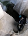
Pretty straightforward really. You get to rap right off of the trail which is funny, but it is a filthy rappel (just hard steep dirt 50ft). The second is a really nice clean dry fall of about 50ft. The small bushes needed to be backed up together to make a safe anchor. The rest is easy going zig zagging through a brush free canyon. Super ugly pot farm on the way down though, lots of trash. It dumps you off right at the start of Lower Fusier Canyon.
One of these days I want to do a car shuttle and leave a car at Mount Gleason and drive back to Tujunga canyon Road and hike all the way up, including Gleason, Iron, Condor (maybe little condor) and Fox. Or if I am feeling lazy do it in the opposite direction, the car shuttle would be easier.