
that would be Cattle Canyon, same place I was mentioning. Was the bulldozer trying to go up Baldy, or one of the side ridges?
there be tungsten in them hills...
BALDY - Archive of Mt. Baldy-related Discussions
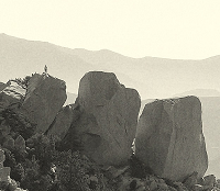
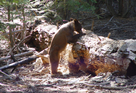
This photo was taken from above looking down with an 18x Zoom. There is a lot of yellow machinery including a bulldozer.
Click on the photo to get a bigger view. I am not sure this is what you saw but, I am pretty sure this is the canyon and right in the green circle, in the photo you posted and I was directly above.
Click on the photo to get a bigger view. I am not sure this is what you saw but, I am pretty sure this is the canyon and right in the green circle, in the photo you posted and I was directly above.
Thanks Ze, had a feeling you were right, I'm just terrible with maps...
Asbufra, that is a cool pic... at first glance, alien space ship photography came to mind
It's now settled, we know where Elvis is... they need the bulldozer to get him his sandwiches and other 'supplies'.
Could bin Laden be in one of those Ice House Canyon cabins... ???
Asbufra, that is a cool pic... at first glance, alien space ship photography came to mind
It's now settled, we know where Elvis is... they need the bulldozer to get him his sandwiches and other 'supplies'.
Could bin Laden be in one of those Ice House Canyon cabins... ???
-
gaudzdice51

- Posts: 10
- Joined: Thu Mar 26, 2009 7:30 pm
A couple of my friends and I were curious about the plane crashes that occurred a while back on Baldy. I've seen the website where the guy visits them, but he doesn't give any description as to where they are..maybe it's like that for a reason, but if anyone knows, please let me know!!
Thanks
Thanks

I think there's a C46 on the north face between Baldy and W Baldy.
Two Hellcats crashed in Goode Canyon, along the top of the Ski Hut Trail on Baldy. When you're hiking up to the summit, you'll see a sign on the south ridge (south of the summit by a mile maybe) saying "Ski hut Trail" or something. Look directly west into the canyon, and viola.
Two Hellcats crashed in Goode Canyon, along the top of the Ski Hut Trail on Baldy. When you're hiking up to the summit, you'll see a sign on the south ridge (south of the summit by a mile maybe) saying "Ski hut Trail" or something. Look directly west into the canyon, and viola.

-
gaudzdice51
- Posts: 10
- Joined: Thu Mar 26, 2009 7:30 pm
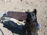
It wouldnt happen to be this sign would it?
-
gaudzdice51
- Posts: 10
- Joined: Thu Mar 26, 2009 7:30 pm
My bad friendowl..didn't see your post. But I have an idea of where it is, and a rough image in my head from Saturday.
Thanks again.
Thanks again.
http://socalhikes.com/2008/12/mt-baldy- ... ter-ridge/
you can look at the gps coordinates / map here. you'll see how we dropped down the west side of the south ridge, that's where the remnants are.
you can look at the gps coordinates / map here. you'll see how we dropped down the west side of the south ridge, that's where the remnants are.
-
gaudzdice51
- Posts: 10
- Joined: Thu Mar 26, 2009 7:30 pm
Cool. Can't wait to check it out. Thanks again.
We stopped in the Mt. Baldy Visitors Center this morning to get a wilderness permit. They have a new book for sale: "Images of America Mt. Baldy". It has lots of old pictures of Camp Baldy, the Icehouse Canyon resort, the Summit Inn (on the summit!), the 1938 flood, etc. I think anyone interested in the San Gabriels would want a copy. With tax, it came to $24.03.
-
seadweller
- Posts: 48
- Joined: Thu Feb 28, 2008 9:28 am
hi,
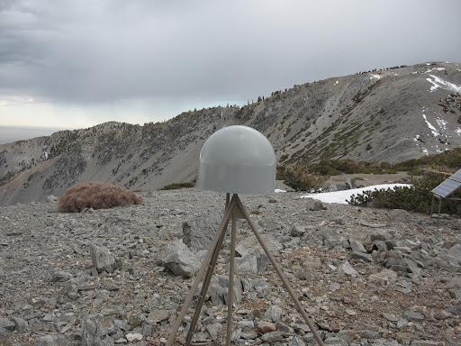
I saw some pics of some scientific equipment on top of either Harwood or West Baldy peak, I do not know which one. Can you tell me where the equipment is located? I want ot hike to it and take some pics and how do you get to it from the Peak of Baldy?
thnx
seadweller
I saw some pics of some scientific equipment on top of either Harwood or West Baldy peak, I do not know which one. Can you tell me where the equipment is located? I want ot hike to it and take some pics and how do you get to it from the Peak of Baldy?
thnx
seadweller
-
seadweller
- Posts: 48
- Joined: Thu Feb 28, 2008 9:28 am
YUP!! This is it .... how do I get to Harwood from Baldy? I have been up the Devil Backbone many times, so where exactly is harwood??
thnx
thnx
Do you have a map of Baldy area? If not, use google earth, look for Mt Baldy, and then look east a little.seadweller wrote:YUP!! This is it .... how do I get to Harwood from Baldy? I have been up the Devil Backbone many times, so where exactly is harwood??
thnx
-
seadweller
- Posts: 48
- Joined: Thu Feb 28, 2008 9:28 am
ok,
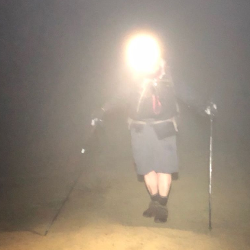
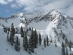
look at these photos .. compared to the person in each of them, where is Mt Harwood?
Also, is there a sign that you pass on Devil Back bone trail that leads to Mt Harwood?
thanks,


look at these photos .. compared to the person in each of them, where is Mt Harwood?
Also, is there a sign that you pass on Devil Back bone trail that leads to Mt Harwood?
thanks,

In the first picture there are four guys coming around the corner from the saddle between the last approach between Harwood and Baldy. They are heading east back to the Ski Lift area with Devils Backbone between them and the Ski lift. If you were to turn around from where they are at in that first picture and head approximately 100 to 200 yards there's a faint use trail that follows the spine coming away from the saddle to the summit of Harwood.
The other way up (that is just as easy) is to come off Devil's Backbone and as you approach the position of the guy in the first picture standing by himself looking uphill at the summit of Harwood - about 50 to 75 yards to his right as he's facing that summit in the picture is another "Faint Use Trail" that is harder to see but if you look close you can find it. The best way I can describe it is to notice that the trees are thinning out look to your right. The guy standing there taking the picture would have it just behind him about 40 yards. It's just before all the excess "Scree" and I think it goes between two trees.
You can find it, it's not that big a trail but it's hard to miss when you look for it.
Enjoy
Lilbitmo

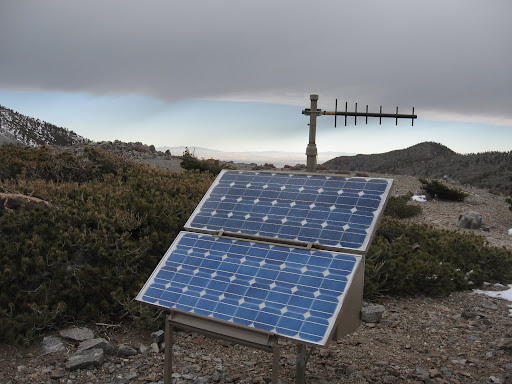
The Harwood EarthScope station had been there about a year now (I think) and it's already been trashed, either by the wind or by (more likely) hooligans. The top solar panel is smashed up and on the ground and the sign explaining the station is broken into pieces.

What? Not a Barrett .50?TacoDelRio wrote:USFS wouldn't need to pay me much to chill up there with a .308 to deter vandalism. Cheaper than building a new one.
I'm going to take the high road here and "Guess" that that damage was done by the wind and weather, not that many of the "Knuckleheads" go up to Harwood compared to the main mountain - i.e. Baldy Proper.
I've been on Harwood when gust were over 60 miles an hour, that cap is so open to the canyon that wind just "Whistle" thru there. When I was up there 2 months ago with Zach we were being pelted by Ice Crystals and small rocks that skip along the top of the surface of the deep snow and icy surface - when the wind blows from the west to the north east it picks up small stuff and carries it down into that canyon, then when the winds picks up in the opposite direction (which are usually stronger from the desert to the Ocean) it turns that debris into "Flying Shrapnel". So it's my guess that those panels and that sign are taking a beating from the weather not "Vandals"
Just my opinion?