
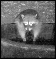
This is actually a very interesting story. This mountain lion incident occurred on Monday evening, Aug 25 on Glendora Mountain Road. The guy on the bike is a good friend of mine and is part of our Boy Scout troop. The KNBC headline sounds like the biker outran the cat. Didn't happen that way...
The short story: Two guys from our troop were taking a late afternoon ride on GMR. The first person (who relayed this in an email and by phone to me) was ahead of the second by a minute or so and didn't see the incident. The second bicyclist was heading southbound (downhill) when the cat jumped down from an embankment. The cat landed next to the moving bike (in the southbound lane) and then bounded OVER the bike and rider. Everything happened in a flash. The bike had a headlight on in the strobe setting so there is no reason the cat couldn't see the bike coming. Interestingly, the first bike reported a coyote moving northbound at about the same spot as he passed through. Was the cat focused on the coyote and didn't see the bike? The second bike didn't see any coyote but, of course, he was distracted by a mountain lion. The next night the bicyclist took a DFG biologist to the spot on GMR where the incident occurred. Sure enough they found cat tracks the size of a compact disc!
The second bicyclist left the country on business and will be back in a couple of weeks. I will get his story and relay back to the list if anyone is interested.
Misc. News (Archive)
-
FIGHT ON
Mike P wrote:This is actually a very interesting story. This mountain lion incident occurred on Monday evening, Aug 25 on Glendora Mountain Road. The guy on the bike is a good friend of mine and is part of our Boy Scout troop. The KNBC headline sounds like the biker outran the cat. Didn't happen that way...
The short story: Two guys from our troop were taking a late afternoon ride on GMR. The first person (who relayed this in an email and by phone to me) was ahead of the second by a minute or so and didn't see the incident. The second bicyclist was heading southbound (downhill) when the cat jumped down from an embankment. The cat landed next to the moving bike (in the southbound lane) and then bounded OVER the bike and rider. Everything happened in a flash. The bike had a headlight on in the strobe setting so there is no reason the cat couldn't see the bike coming. Interestingly, the first bike reported a coyote moving northbound at about the same spot as he passed through. Was the cat focused on the coyote and didn't see the bike? The second bike didn't see any coyote but, of course, he was distracted by a mountain lion. The next night the bicyclist took a DFG biologist to the spot on GMR where the incident occurred. Sure enough they found cat tracks the size of a compact disc!
The second bicyclist left the country on business and will be back in a couple of weeks. I will get his story and relay back to the list if anyone is interested.
I've seen cat prints that big
http://fighton.smugmug.com/photos/361113038_vLwRX-L.jpg

-
Terry Morse
- Posts: 126
- Joined: Mon Mar 03, 2008 8:55 pm
So, it sounds like the mountain lion wasn't even interested in the cyclist.
But, that story doesn't sell newspapers, does it?
But, that story doesn't sell newspapers, does it?
Yup, you would think a mountain lion wouldn't miss in this type of situation.Terry Morse wrote:So, it sounds like the mountain lion wasn't even interested in the cyclist.
But, that story doesn't sell newspapers, does it?
Anyhow, I will get the straight scoop from the cyclist when he gets back.
Buckhorn in Angeles National Forest
http://travel.latimes.com/articles/la-t ... -2008sep07
"The Burkhart Trail high above the San Gabriel Valley leads to Cooper Canyon Falls, a clear, bracing swimming hole"
OT: Missing Hiker Found Dead In Falls Creek
http://cbs2.com/local/Missing.Man.Forest.2.811609.html
"FOREST FALLS Acting on a tip from a Norco man, searchers Sunday found the body of a hiker last seen Monday in a rugged canyon in San Bernardino County, according to a sheriff's spokeswoman"
3.1 earthquake-Wrightwood
http://sciencedude.freedomblogging.com/ ... arthquake/
Angeles 2 accidents...
http://www.pasadenastarnews.com/ci_10395745?source=rss
"Big rig slams into 6 vehicles parked at La Cañada Flintridge cafe"
http://www.lacanadaonline.com/articles/ ... al0821.txt
"A 28-year-old Costa Mesa man was killed this week after his motorcycle crossed the double yellow line on Angeles Crest Highway and he was struck by an oncoming truck"
Incidents:
09/07/2008 17:55 ANF-3373 Hang Glider Down Medical Aid Pacoima Canyon Trail
09/07/2008 08:01 ANF-3352 Vandalized Vehicle Miscellaneous San Gabriel Canyon Rd at Curve Gate MM 28.76
Speaking of vandalized vehicles.....heres a cross-post from canyoneering about parking along BigTujunga canyon road......
"It's been posted here before that break-ins are more common in the Big Tijunga area.
Just to let y'all know, the trend is still strong, if not outright rampant. Today, 2 of 3 cars had broken windows and valuables were absconded with while Great Falls Foxing.
In my case, nothing of value was visible, so they were smashing windows and ransacking just to see what they can find. In the future, I recommend treating your vehicles like a jeep - unlock all doors, roll down windows (weather permitting) and leave your car as empty as possible when canyoneering in this area."
No need to mention graffiti/littering/dumping is there?
-
FIGHT ON
I like earthquakes.
I hate car break ins.
Guess should have added in....
"Arroyo bridge to be replaced"
http://www.lacanadaonline.com/articles/ ... dge724.txt
"The city of Pasadena will spend $1.1 million to replace a bridge over Arroyo Seco Creek, located in the canyon behind the Jet Propulsion Laboratory.........She said she was also concerned about potential city liability from hikers who continue to use the bridge despite warning signs."
Q: What happened to that wilderness bill?
A: Congress comes back in September. Thats when the opposition will be able to jump in and we will see what happens. I only read MTBers dont like it(Burkhart trail), and OHVers dont like it(Furnance creek road), maybe others out there. In addition the closure affecting Williamson Rock remains until this bill settles out...http://williamsonrock.org/blog/
"Input sought on Monrovia Wilderness Preserve plan"
http://www.pasadenastarnews.com/ci_10340885
"The preserve is bounded by the Angeles National Forest to the north, the Monrovia-Bradbury border to the east, hillside properties to the south and the Monrovia-Arcadia border to the west"
"Forest Service diverts money to pay for wildfires" - OC Register
http://hosted.ap.org/dynamic/stories/F/ ... TE=DEFAULT
"The cost of fighting large fires in California and elsewhere is forcing the U.S. Forest Service to divert hundreds of millions of dollars set aside for work including roads, trails, recreational improvements - even fire prevention...Spending on all non-critical items for the rest of the year must be curtailed, Kimbell told foresters"
Q: Is climbing illegal in the whole ANF?
A: Jeez....I was surprised to hear of this one....seems very suspect though...but certainly curious....got me to write an email.
Microblog....
http://eastofallen.blogspot.com/
historical info re: the front range i.e. Eaton,etc
"Though well established on the east coast, at the age of 54, Cogswell again moved west. In 1873 he purchased 473 acres of wild mesa land in what is now east Pasadena. In its natural state, this land was said to be covered with greasewood so thick a jack rabbit couldn't penetrate it. "
"As the Field Guide to the San Gabriel Mountains points out, in 1927 the U.S. Board on Geographic Names ended the controversy and ruled the mountains would be officially known as the San Gabriels."
"Grade is site of many brakeless crashes"-Hwy 2 at the bottom...
http://www.lacanadaonline.com/articles/ ... bar911.txt
"“I have seen six to eight [similar] accidents at this corner,” said Darren Silversparre, who has worked at the Union 76 station on Foothill at ACH for 30 years. “[Big trucks] pick up so much speed coming down the ’Crest"
"Runners test endurance"
http://www.whittierdailynews.com/ci_10463552?source=rss
"The winner of the race was 32-year-old Hal Koerner of Ashland, Oregon, who finished the course in just under 18 and a half hours."
"Senate Committee Approves Three Bills to Protect Wilderness and Wild & Scenic Rivers Across California".........so it will be for a Senate vote and is still in a House committee....
"Motorist arrested after car plummets in San Gabriel Mountains"
http://www.pasadenastarnews.com/news/ci_10413954
"The California Highway Patrol shut down a mountain road for three hours and arrested a driver after he drove a car down the side of Glendora Mountain Road this morning.
Officers closed Glendora Ridge Road at Mt. Baldy Road in the San Gabriel Mountains north of San Dimas following the 12:25 a.m. crash. The CHP said the driver plunged down the side of Glendora Mountain Road at Glendora Ridge and received injuries.
The charge the driver was suspected of was not immediately available"
Wasnt this car though....
http://rrpj.blogspot.com/2007/10/car-over-side.html

-
JMunaretto
- Posts: 370
- Joined: Thu Feb 07, 2008 11:03 am
can't believe out of all those accidents there were so few fatalities!
Bears, lions, coyotes....
http://cbs2.com/local/Bear.San.Dimas.2.820167.html
http://www.lacanadaonline.com/articles/ ... te0911.txt
"Strong said the cat was a male, about 125 pounds. He added that although his family’s property is adjacent to the Angeles National Forest he has never seen a mountain lion get so close to the compound....Coyotes are not uncommon in the foothills, but in two recent cases they have turned aggressive, surprising their victims"
incident:
09/18/2008 09:32 ANF-3503 Possible Aircraft Down Aircraft Down ACH/ACH Clear Creek Vista area mm 32,60
website: http://www.habitatwork.org/
Volunteers cleaning things up....not that vandals shouldnt be a key subejct, but people who clean stuff up should also get some mention from time to time.
I also noted that Matilija creek in Ojai may be suffering from access issues..the hike was removed from localhikes.com..however if interested, check out http://www.flickr.com/photos/naturalist4you/ for recent pictures....
Man convicted of attacking SoCal hiker with sword
http://www.fresnobee.com/384/story/881292.html
"A man has been convicted of attacking a hiker with a Samurai sword on the Mount Baldy trail in the San Gabriel Mountains"
ACH medians studied
http://www.lacanadaonline.com/articles/ ... ns0918.txt
"Boorrring"
Water in the San Gabriel River
http://www.ci.azusa.ca.us/CivicAlerts.asp?AID=27
"The truth of matter is that the water from the Morris Dam is limited in quantity, and in the overall supply picture, it is literary a drop in the bucket"
There was also a news item that the water level of the SG valley is close to a record low.
OT: Cliff collapse at Torrey Pines State Beach
http://www.signonsandiego.com/news/metr ... riefs.html
"Authorities were notified of the collapse about 10:30 a.m. Up to 100 tons of earth may have fallen onto the sand....It is the second collapse at Torrey Pines State Beach in the past month. A tourist from Nevada was killed Aug. 20, when a section of the cliffs fell as he sat on the sand in a narrow area near Flat-rock just north of Black's Beach"
"Deep-forest marijuana farms can damage ecosystem after raids, officials say"
http://www.pe.com/localnews/inland/stor ... e.html?npc
"Officials have dismantled more than 30 marijuana farms growing in the San Bernardino National Forest this year, but scientists say the effects on the forest's delicate ecosystem could last for years......Shane Krogen, executive director of the High Sierra Volunteer Trail Crew, and his volunteers remove tons of garbage, chemicals and irrigation lines left behind from marijuana-farm busts, but they can only get to a small number of sites."
Purchased Azusa parcel to join network of trails along rivers
http://www.sgvtribune.com/ci_10553449?source=rss
"The property, at 2330 N. San Gabriel Canyon Road, is part of the Emerald Necklace, a 17-mile network of trails along the Rio Hondo and San Gabriel rivers that will unify more than 1,500 acres of parks, open spaces and habitat corridors.
Officials on Wednesday celebrated the acquisition of the Canyon Inn and Cool Springs Property by commending the Watershed Conservation Authority and other local and state agencies that contributed to the purchase of the land."
Water drought
http://sciencedude.freedomblogging.com/ ... e-drought/
http://www.pasadenastarnews.com/ci_10580551?source=rss
"Feds say O.C on verge of “severe” drought"
""Money is always a key factor in anything political," said Charles Trevino, who as of June collected $39,000 and is the top fundraiser among the candidates running for the El Monte-based Upper San Gabriel Valley Municipal Water District. "I am prepared to spend between $80,000 to $100,000 if I have to." "
Wind energy gets boost with major transmission line
http://www.tehachapinews.com/home/ViewPost/76326
"In documents tracing the progress of the $2 billion project......The only federal land the transmission line will cross is the Angeles National Forest, south of the Antelope Valley"
Nother break in news...Ventura county...I think this affects Santa Paula canyon...
Thomas Aquinas trailhead again scene of multiple vehicle burglaries
http://www.santapaulatimes.com/news/ful ... aries.html
"According to the VCSD, 11 vehicles parked at the trailhead have been broken into during the past three weeks. Investigators believe burglars are waiting for hikers to park their cars and walk away before smashing windows and stealing valuables. The burglars seem to prefer cash, jewelry, iPods, credit cards and personal information that can later be used for identity theft.......In that series of vehicle burglaries, law enforcement learned that the thieves cased the area, watched the victims, and even placed lookouts before they smashed a window."
Hwy2: Post of de day
http://www.wrightwoodcalif.com/forum/in ... 7.285.html
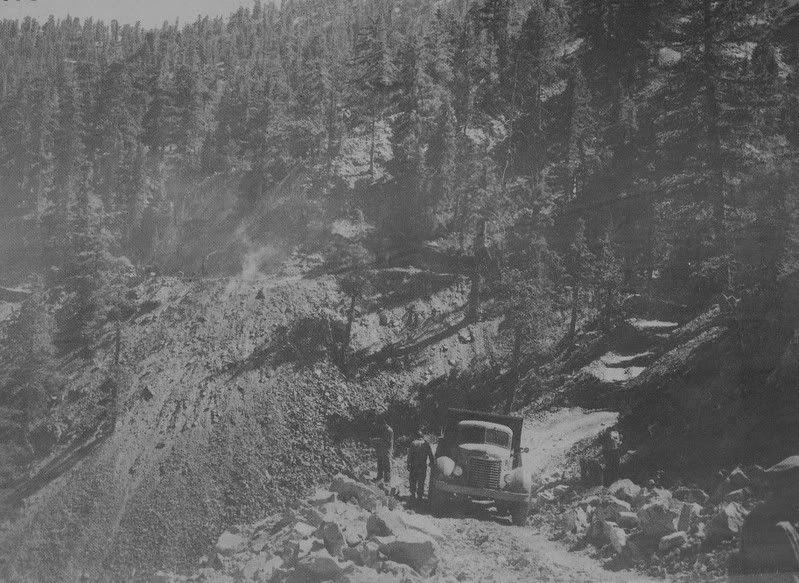
Picture of Hwy 2 awhile back....(1940s!)
http://i122.photobucket.com/albums/o267 ... an0068.jpg
http://www.pe.com/localnews/inland/stor ... e.html?npc
"Officials have dismantled more than 30 marijuana farms growing in the San Bernardino National Forest this year, but scientists say the effects on the forest's delicate ecosystem could last for years......Shane Krogen, executive director of the High Sierra Volunteer Trail Crew, and his volunteers remove tons of garbage, chemicals and irrigation lines left behind from marijuana-farm busts, but they can only get to a small number of sites."
Purchased Azusa parcel to join network of trails along rivers
http://www.sgvtribune.com/ci_10553449?source=rss
"The property, at 2330 N. San Gabriel Canyon Road, is part of the Emerald Necklace, a 17-mile network of trails along the Rio Hondo and San Gabriel rivers that will unify more than 1,500 acres of parks, open spaces and habitat corridors.
Officials on Wednesday celebrated the acquisition of the Canyon Inn and Cool Springs Property by commending the Watershed Conservation Authority and other local and state agencies that contributed to the purchase of the land."
Water drought
http://sciencedude.freedomblogging.com/ ... e-drought/
http://www.pasadenastarnews.com/ci_10580551?source=rss
"Feds say O.C on verge of “severe” drought"
""Money is always a key factor in anything political," said Charles Trevino, who as of June collected $39,000 and is the top fundraiser among the candidates running for the El Monte-based Upper San Gabriel Valley Municipal Water District. "I am prepared to spend between $80,000 to $100,000 if I have to." "
Wind energy gets boost with major transmission line
http://www.tehachapinews.com/home/ViewPost/76326
"In documents tracing the progress of the $2 billion project......The only federal land the transmission line will cross is the Angeles National Forest, south of the Antelope Valley"
Nother break in news...Ventura county...I think this affects Santa Paula canyon...
Thomas Aquinas trailhead again scene of multiple vehicle burglaries
http://www.santapaulatimes.com/news/ful ... aries.html
"According to the VCSD, 11 vehicles parked at the trailhead have been broken into during the past three weeks. Investigators believe burglars are waiting for hikers to park their cars and walk away before smashing windows and stealing valuables. The burglars seem to prefer cash, jewelry, iPods, credit cards and personal information that can later be used for identity theft.......In that series of vehicle burglaries, law enforcement learned that the thieves cased the area, watched the victims, and even placed lookouts before they smashed a window."
Hwy2: Post of de day
http://www.wrightwoodcalif.com/forum/in ... 7.285.html
Picture of Hwy 2 awhile back....(1940s!)
http://i122.photobucket.com/albums/o267 ... an0068.jpg

Thanks for that link to the discussion & pics of the bridge being constructed west of Vincent Gap. I for one can hardly wait for that highway to open. For one, I suspect that car break-ins at Islip Saddle will decrease. Or perhaps they'll increase - how the hell would I know? 
p.s. HJ - didn't know you were an Aggie - Gig 'em!
p.s. HJ - didn't know you were an Aggie - Gig 'em!
-
FIGHT ON
They could even stay the same. Or fluctuate! Actually if it was going to change I think it would get worse because they could exit either way instead of having only one escape route!HikeUp wrote: For one, I suspect that car break-ins at Islip Saddle will decrease. Or perhaps they'll increase - how the hell would I know?
Oh, yes. I suppose I'm not quite as "loud" about such things as someone who shall go unnamed.HikeUp wrote:p.s. HJ - didn't know you were an Aggie - Gig 'em!
By the way, that forum is what led me to my dad's backpack, over three years after his accident. There are some really nice folks over there.
OT: Yosemite rockfall slams Curry village-3 minorly hurt
http://www.sfgate.com/cgi-bin/article.c ... d=rss.news
"Gerald Wieczorek of the U.S. Geological Survey, an expert on Yosemite rock slides, said even large slides are "not unusual" at Yosemite and that substantial slides can occur as often as a dozen times a year.....The slide occurred shortly before 7 a.m., sending an estimated 1,800 cubic yards of debris - equal to about 200 dump-truck loads - into the area near the village amphitheater and cafeteria, park spokeswoman Adrienne Freeman said. Two wooden cabins and five tent cabins were destroyed...
In July 1996, a slab of granite weighing as much as 162,000 tons broke loose from Glacier Point and plummeted onto the Happy Isles area about a mile east of Curry Village. ....."
Addntl coverage...
http://littleredtent.net/LRTblog/
http://www.yosemiteblog.com/
A 2006 rockslide....
http://geology.com/articles/yosemite-rockfall.shtml
OT:Local woman describes mountain ordeal
http://hanfordsentinel.com/articles/200 ... 358650.txt
"Hiking her favorite trails in the San Gabriel Mountains near Los Angeles, 58-year-old Hanford resident Karen Lafferty never worried about the weather. It was warm and dry. The last thing on her mind was hypothermia. But on Friday on the Pacific Crest Trail near Lake Tahoe, at more than 8,900 feet above sea level, a bitterly cold rain blowing in gusts of nearly 100 miles per hour, the temperature with the wind chill dropping well below freezing, it was a different story......Lafferty said she planned to go backpacking again, but she's learned some hard lessons.
One is the importance of staying together and regrouping.
Another is having a storm-worthy tent"
OT: Los Padres/Santa Barabra
Big Cats on the Prowl
http://www.independent.com/news/2008/se ... ats-prowl/
"The Forest Service released an advisory this week warning of an increase in mountain lion sightings in Santa Barbara County."
Back to the weather forecast...
"We had driest summer"
http://www.lacanadaonline.com/articles/ ... er1002.txt
"This was the driest spring and summer in California history,” Patzert said. “Looking ahead for the winter [we see] yet another below normal rainfall.” According to the U.S. Drought Monitor, California is facing severe drought conditions...The rainy season for California, which is predicted to be mild, begins in January but the Santa Ana wind conditions are in October"
From Gary Valle:"Update 10/06/08. Saturday's trough and front behaved about as expected with scattered light rainfall around the area. Precipitation amounts generally ranged from a trace or less to about 0.1 inch or so in some foothill and mountain locations."
Incidents:
10/05/2008 17:34 ANF-3737 Radiological Activity Hazmat 37700 Templin Hwy btwn LA DWP Road and Fisher Spg TT
other than that same ol same ol with high visitation continuing on the weekends..."10/05/2008 12:47 Full Capacity Switzers Gate"
Wilderness bill status: put off until next year(decided before the 'bailout')....which throws Williamson Rock into further decision delays....closure extends out until the bill is resolved...granted friends of Williamson Rock not happy...
http://williamsonrock.org/blog/
One more...highway 39 to Crystal Lake
"The projections is that March of 2010 is the re-opening date "
http://www.crystallake.name/forum/read.php?13,27
"Caltrans still has the highway 39 blocked at around mile marker 29 and they continue to work on the footing of the bridge that's just past their closure. That is scheduled to be completed at the end of October and then Caltrans moves up the highway .....(thats to mm 32.12)
Sept pic of Crystal Lake
http://www.crystallake.name/forum/read.php?5,17
Assembled a posting and had an IE startover error..so just some topics then...
1)Marek fire...also Porter Ranch fire started with 1 homeless dead..didnt see anything on closures such as Sierra Madre.
2)Caltech scenario about 7.8 quake & the cajon pass...really bad
3) S&R - Lytle Creek/Bonita Falls(2 rescued above lowest waterfall..at 1 am or so no less)
Chaney/Mt. Lowe Trail(Altadena)
Bridge to Nowhere(Asuza)
Sycamore Canyon/Guadalasca Trail(Thousand Oaks I think)
Victory trailhead & Valley Circle(Northridge)
4) Other incidents
Rockruns Miscellaneous Highway 39 mm 24.19
Mt Baldy Road/Hogsback and the Tunnel area
campfires....a lot of incidents, they appear to be checking everything
Wasps in restrooms Miscellaneous ACH mm 50.50 (did someone actually call the cops on this one?)
10/09/2008 08:45 ANF-3768 Old dynamite/detonators Hazmat Tungsten/Curtis Mines...Cattle Cyn/Sheep Mtn Wilderness area
5) LA River - drama over suspension of fed employee who kayaked LA river.
Got any more info on #5?AW wrote:Assembled a posting and had an IE startover error..so just some topics then...
1)Marek fire...also Porter Ranch fire started with 1 homeless dead..didnt see anything on closures such as Sierra Madre.
2)Caltech scenario about 7.8 quake & the cajon pass...really bad
3) S&R - Lytle Creek/Bonita Falls(2 rescued above lowest waterfall..at 1 am or so no less)
Chaney/Mt. Lowe Trail(Altadena)
Bridge to Nowhere(Asuza)
Sycamore Canyon/Guadalasca Trail(Thousand Oaks I think)
Victory trailhead & Valley Circle(Northridge)
4) Other incidents
Rockruns Miscellaneous Highway 39 mm 24.19
Mt Baldy Road/Hogsback and the Tunnel area
campfires....a lot of incidents, they appear to be checking everything
Wasps in restrooms Miscellaneous ACH mm 50.50 (did someone actually call the cops on this one?)
10/09/2008 08:45 ANF-3768 Old dynamite/detonators Hazmat Tungsten/Curtis Mines...Cattle Cyn/Sheep Mtn Wilderness area
5) LA River - drama over suspension of fed employee who kayaked LA river.
-
JMunaretto
- Posts: 370
- Joined: Thu Feb 07, 2008 11:03 am
http://www.whittierdailynews.com/news/ci_10674208AW wrote: 2)Caltech scenario about 7.8 quake & the cajon pass...really bad