The closure between pm 61 and 64 should be in place for a few months. I will have more information in the following weeks. Once the lower section opens, I should have more time to devote to the project at 40.35 and 61.
i was up there today, actually. 2 is open from switzer to a few miles past charlton flats. i took some pics but i don't think they show much of consequence. if anyone wants to see, just hit me up and i'll upload em.
I hope it does open up...I will be up there on sunday if it does. I am curious to see the changes since the fire. It will look like a new place im sure.
The actually opened the damned thing today. I went up Tujunga Canyon Rd. because the Crest was not going to open from La Canada until after a ceremony at 10 AM. Bit I did drive down all the way in the afternoon. Lots of new pavement.
MattCav wrote: ↑Hey alan, was the 2 reopened at eagles roost?
I only went up as far as Three Points. I had limited time and did about 8 miles on the PCT. I hope they managed to open the rest of the 2 past Eagles Roost -- I got stuck there a few weeks ago.
actually, it is open thru from Glendale to Wrightwood. They have a 1 lane flagging area at eagles roost with alternating traffic. It's pretty sketchy, but it was open today around noon.
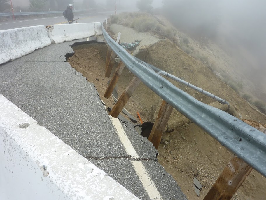
Looks like this caught everyone off guard, including both the PIO's who were obviously completely blind sighted. There were 4 separate press releases today until the 2 Cal-Trans districts got on the same page and figured out what happened and who opened whose gates.
Glad it's open, and appreciate the hard work, but for the sake of the children, please learn to communicate with each other Cal-Trans.
MtnMan wrote: ↑actually, it is open thru from Glendale to Wrightwood. They have a 1 lane flagging area at eagles roost with alternating traffic. It's pretty sketchy, but it was open today around noon.
Looks like this caught everyone off guard, including both the PIO's who were obviously completely blind sighted. There were 4 separate press releases today until the 2 Cal-Trans districts got on the same page and figured out what happened and who opened whose gates.
Glad it's open, and appreciate the hard work, but for the sake of the children, please learn to communicate with each other Cal-Trans.
Between MM40 and MM41 (about 2 miles east of Redbox, there is a 1 lane section of ACH (huge-normous pile of dirt on the west bound lane for some reason). There are stop lights at each end or, when the workers are there, there are flagmen controlling traffic. I experienced no delays at 5:30a this morning or at 12:45p this afternoon. Saw about 4 or 5 CHP motorcycles watching for speeders between 3 Points and La Canada - I was wondering why I was driving faster than the crotch rockets
Heading up the 2 this Sunday for a few nights at Little Jimmy Camp out of Islip Saddle. With some snow forecast for Sunday evening, I'm wondering, historically speaking, how much snow does it usually take before Caltrans shuts it down and where? Once it is shut down, is that it for the season, or do they reopen if conditions improve? I'd hate to get back to the car and find that we were locked in. Anyone have any experience with this? Thanks.
The only closures I have seen are the full time winter closure of the 2 between Islip Saddle and Vincent Gap. I do not know when this occurs but I would think it is still open even with this upcoming storm. Temporary closures of other parts of the 2 during the winter may occur but are rare unless a slide takes out part of the road.
This is just my experience and there are no guarantees
The historically went to the hell when that bitch burned the forest down! So now its time to play the winter ACH closure game. Where will the next closure be? Take the opportunity now and go for a scouting drive, look around where is that section that can not stay put when the water comes pouring down. Our wonderful FS has planted some clues as to where the closure will happen by placing a few new extra locking gates at various spots on hwy . Please, do take the opportunity and hike somewhere along the ACH(but NOT in the restricted areas) cause if a closure happens, we know now, that historically it will be years before the ACH hwy opens again to the public!
You will never be locked in cause we have this wonderful free service called search and rescue that will help you to get back in the city.
From the past winters the ACH usually closes just beyond the Islip Saddle parking lot- you will see the gate when you park your car at Islip Saddle,so you will be ok for now. Just put a note inside your car that you are going to Little Jimmy just in case a freak storm develops and we get lots, lots of snow. It might be a wise idea to bring a shovel or two just in case you need to clear a section of the parking lot so you can get out on the hwy. Hint- park close to the road.! Usually there is a sign at the start of the ACH telling you how far in you can go. The forrest service does a wonderful job in making sure you will ok where and when ever you go in the forrest, this is not a major storm so no need to worry much.
Go up there and enjoy this wonderful winter wonderland!
Cal-Trans put up those gates on Hwy 2, not the FS.
As to when it will close, it's anyone's guess. The first storm we got in Oct put down 6"+ above 7,000 ft, but it was too little snow and too early in the year to close it for the season.
My guess is if we get about 8" or more, it will probably close now since the sun angle is super low and we are nearing December with the likelihood of more frequent storms and consistently cold temperatures.
As far as being locked in, as others have said, you'd probably be fine at the parking lot of Islip Saddle in a small storm as the gate is just east of that parking lot.
However, if we get a decent amount of snow with low snow levels, sometimes they close the road lower down and concentrate on keeping that section clear first, since there are basically no services or residences past the 6,000 ft mark (and the ski area is not open yet, obviously).
Keep an eye on the weather as they are now saying this storm may be put out more rain/snow than they have been thinking.
If you go, as others have said, leave a note on your dashboard, and be prepared to have to walk out the hwy, as you just don't know what Cal-trans is going to do.
SR 2
[IN THE SOUTHERN CALIFORNIA AREA]
IS CLOSED FROM ISLIP SADDLE TO 5 MI WEST OF BIG PINES (LOS ANGELES CO) - DUE TO SNOW - MOTORISTS ARE ADVISED TO USE AN ALTERNATE ROUTE
Well, when mother nature blanketed the mountain stage in white, they got stage freight and did not go. Hey, if thats the case, plz go there this weekend it should be an easier trek. Going to BP in one day its very tough, you could try to go as far to Throop and back. Beyond that it roller coasters up and down,ascends, faces north and its shaded. If the trail disappears with a lot of snow you need to know where to go and even so its kind of tough going. Another conservative option would be to go to Mt Islip.
MM MAN, thanks for the update, plz keep us informed of any new closures there.... 666
Well, as The Beast suggested, once we got to the trailhead on Sunday morning, Hiking Buddy decided that the oncoming storm was a little to rich for his blood, so we dropped down a few thousand feet and camped at Chilao. I went back up on Tuesday to check it out and hike up to Little Jimmy and scope out the conditions. Road was open up to Islip Saddle but the gate there was closed. Caltrans seemed to be working both sides of the gate though, so maybe it's not completely over for the season. On the hiking side of things, conditions were perfect with 6-8" of virgin powder blanketing the trail, which was easily followed.
according to Cal-Trans, Hwy 2 is re-opened again from Islip to Vincent. I guess it wasn't enough to close it for the season, plus maybe the fact it looks mostly dry and warm for the next week or so at least.
San Bernardino County – Caltrans District 8 is closing the section of State Route 2 (SR 2) between Vincents Gap and Islip Saddle today for the winter. This stretch of mountain highway, located west of Wrightwood, closes every winter due to avalanche activity and concern for motorist safety.
It is also a difficult section of roadway for maintenance workers to keep maintained due to the demands on Interstate 15 in the Cajon Pass, State Route 138, and SR 2 through Wrightwood during inclement weather.
SR 2 has sustained damage in recent years from avalanche activity resulting in road loss. In the event that this occurs the opening could be delayed. Caltrans will alert the public once SR 2 is ready to reopen, expectedly in spring 2012.
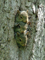
I spotted them as I was exiting the forest going west near the Red Box area. I only managed to take pic the 2 of the 3, too slow of a cam.
I have seen the Porsche, GM caravans on the ACH, must be a test drive route, the cobras were out for a fun drive on the crest!