

No info on the ANF site or the CalTrans site. Hmm.
Just to help clarify where this is...I don't think you were at Cloudbusrt (but I could be mistaken). Cloudburst is about 1 mile before Buckhorn and the PCT does cross there, but there is not a huge parking lot. The huge parking lot (on the south side of the rode) is about 4 miles before Buckhorn and a little more than a mile past Three Points. The PCT does cross at the huge parking lot, and there is a gate across the road at the east end of the lot. So it looks like you could get as far as 1 mile or so past 3 points.
Can you say Twin Peaks?
Angeles Crest Highway (CA-2)
-
cougarmagic

- Posts: 1409
- Joined: Wed May 07, 2008 5:21 pm
Yes, HikeUp has it right. That's the place. Well, I'm going to have to go up there tomorrow and find out the hard way. I have a trail cam up there, hoping to see some bighorn sheep. Tomorrow is my last day off for a while, and I am not a patient person...!
So I'll let you know if it's open again.
So I'll let you know if it's open again.
-
Dudley Heinsbergen
- Posts: 109
- Joined: Tue Jan 22, 2008 9:02 pm
this happens the day i plan a trip up to there!
!!!
!!!
There is a post dated 9/3/08 on the wrightwood forums for Hwy2...
"FYI
There's CalTrans gate between Kratka, now Snowcrest, and Vista, now closed, at mile marker 60.23, one just past Cedar Springs at mm 61.45, the one at Islip at 64.10 and none until Vincent Gap at mm 74.80"
Not exactly sure if "Vista" is closed or the road is closed..and didnt say why whatever is closed is closed either.
-
FIGHT ON
Map.AW wrote:There is a post dated 9/3/08 on the wrightwood forums for Hwy2...
"FYI
There's CalTrans gate between Kratka, now Snowcrest, and Vista, now closed, at mile marker 60.23, one just past Cedar Springs at mm 61.45, the one at Islip at 64.10 and none until Vincent Gap at mm 74.80"
Not exactly sure if "Vista" is closed or the road is closed..and didnt say why whatever is closed is closed either.
http://mapper.acme.com/?ll=34.35187,-11 ... tains%20CA
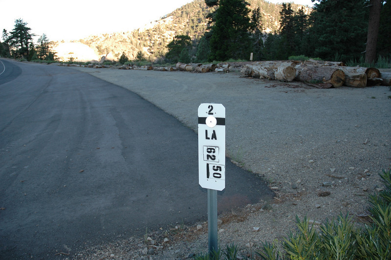
PHOTOS OF MILEAGE MARKERS
A. East road from Buckhorn. (There's another marker on the other side of the road 59.00 which is exactly at the Buckhorn Road.)
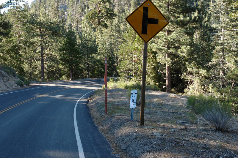
B. Eagles Roost.
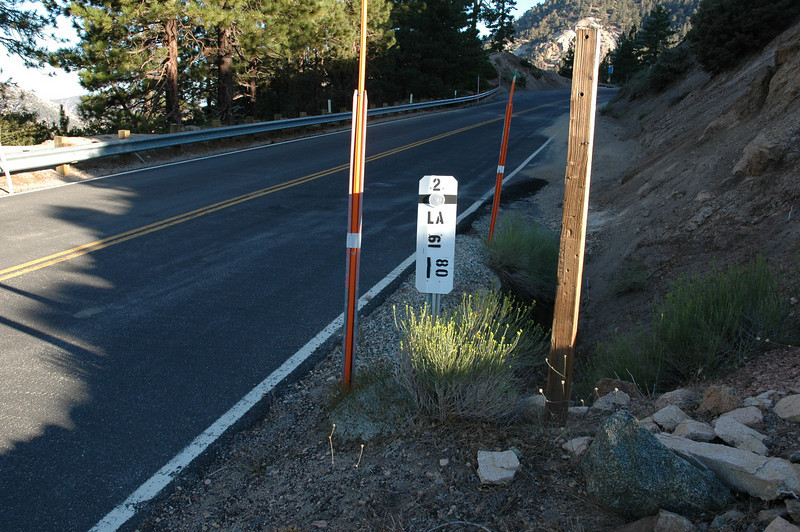
C. Mt. Williamson Trail Parking Lot.
-
JMunaretto
- Posts: 370
- Joined: Thu Feb 07, 2008 11:03 am
Yes, estimating based on her description and the fact that she agreed with my earlier comments. Mile marker 54.02, just east of Three Points by about a mile. I know there is a gate there...she indicated she'll give an update tomorrow. Hope this is clear! Just trying to let everyone know how far they can get if the gate is still closedJMunaretto wrote:Are you estimating based the description above or you heard from other sources?
-
cougarmagic
- Posts: 1409
- Joined: Wed May 07, 2008 5:21 pm
I'll take a photo of the gate & parking area, so you can all share in the frustration.
-
cougarmagic
- Posts: 1409
- Joined: Wed May 07, 2008 5:21 pm
Sorry, I didn't make it up there today. I tried calling a few ranger stations again this morning, but couldn't get any information. I didn't have the heart to spew greenhouse gases all day just to see the closed gate again. THe best guess is that CalTrans is working on the road. It didn't seem like a small thing - like, if there was a small rockslide, they might put up smaller barricades while they clear it, but this gate was CLOSED.
So I'd suggest anyone heading up this weekend have a Plan B hike in mind...
So I'd suggest anyone heading up this weekend have a Plan B hike in mind...
-
JMunaretto
- Posts: 370
- Joined: Thu Feb 07, 2008 11:03 am
NOOOOOOOOOOO!
I was gonna do Waterman and Twin Peaks from Buckhorn. i guess I could still go from three points, maybe just to Twin Peaks and back
I was gonna do Waterman and Twin Peaks from Buckhorn. i guess I could still go from three points, maybe just to Twin Peaks and back
-
FIGHT ON
You gonna miss the game! If you ain't down there by 12 noon you never gonna get in!JMunaretto wrote:NOOOOOOOOOOO!
I was gonna do Waterman and Twin Peaks from Buckhorn. i guess I could still go from three points, maybe just to Twin Peaks and back
-
JMunaretto
- Posts: 370
- Joined: Thu Feb 07, 2008 11:03 am
Gonna watch it - on the tv. After hiking
-
JMunaretto
- Posts: 370
- Joined: Thu Feb 07, 2008 11:03 am
Seriously, what's a decent plan B? My girlfriend is demanding elevation gain. Starting from Three Points is just gonna be too low of a gain/mile, and would take too many miles to get some decent elevation. I'm not sure what else around there (that isn't after this road closure) that could work. Eitherwise I would have to not chance it at all and go hike Ontario or something 
-
FIGHT ON
What ya do is start at 3 points and do a loop going up to Cloud Burst Summit and then over to the trail that goes up to Mt Waterman and then either go up to Twin Peaks or just go back to 3 points. And I bet that road will be open by Saturday anyway. JUST GO! ( Hey J. How long can you balance on one foot with your eyes closed?)JMunaretto wrote:Seriously, what's a decent plan B? My girlfriend is demanding elevation gain. Starting from Three Points is just gonna be too low of a gain/mile, and would take too many miles to get some decent elevation. I'm not sure what else around there (that isn't after this road closure) that could work. Eitherwise I would have to not chance it at all and go hike Ontario or something
-
FIGHT ON
Hey wait a minute. Go do Skyline! She wanted elevation gain right? Well?  I bet Perry would go out of his way to show you up. Maybe ask him.
If you're looking for 750'/mile or more, then you're fucked if that gate stops you. Unless you want to go cross country, then you could head up the west ridge of Waterman from Three Points instead of taking the trail to the Waterman-Twin peaks Saddle. Taking the PCT from the potentially closed gate won't get you much gain per mile, but you can do a lot of distance...say, hit Pallett and Will Thrall ...that'd be a hell of a long distance roller coaster. Get a map!!!!!! 
Screw that shit...PLAN B! Always have an out!Dudley Heinsbergen wrote:this ruins my weekend....
-
JMunaretto
- Posts: 370
- Joined: Thu Feb 07, 2008 11:03 am
Yeah I got a map or two! Yeah I know there's no big gain trails around there that are well known, just thinking maybe something creative could be conjured up.
I am mad! And if I call the ranger station, I know I'll just be more pissed with their incompetence. Last time they told me Heaton Flats was flooded
I am mad! And if I call the ranger station, I know I'll just be more pissed with their incompetence. Last time they told me Heaton Flats was flooded
-
JMunaretto
- Posts: 370
- Joined: Thu Feb 07, 2008 11:03 am
Called the ranger station and they said that normally any closure during the week should be open for the weekend. I hope that's true...

