
Thanks, Alan K!
I was hoping it was a moderate hike. I do tough ones on Saturdays and moderate ones on Mondays or Tuesdays.
Cheers!
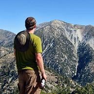
Pacific Crest Trail (Cajon - Little Jimmy - Soledad)

Liz,
That hike will be fun, I did it in the winter with Lucy in 2006 with 8 inches of snow on the ground from Islip Saddle to Baden and down, beautiful area, you will like it.
It was so peaceful being out there with no one else and the road closed made it even quieter.
Enjoy
That hike will be fun, I did it in the winter with Lucy in 2006 with 8 inches of snow on the ground from Islip Saddle to Baden and down, beautiful area, you will like it.
It was so peaceful being out there with no one else and the road closed made it even quieter.
Enjoy
-
Richard N.
- Posts: 91
- Joined: Tue Feb 12, 2008 9:47 pm
The hike is a nice one for sure. You have bathrooms at Little Jimmy and excellent water 1/4 mile before the camp. Fill up, no filtering required.
Not sure what would be the hard spots?? Going up Baden-Powell or up to Dawson Summit after Burnham?
Once you past the cut off to Hawkins its all down hill from there. Remember, from Dawson Summit you can head north to Dawson Saddle and from there add Mt. Lewis in the mix.
I have always done the round trip from Islip. It just seems a lot more fun, 18 miles rather than 13.
No matter what, you will enjoy hiking the roof of the forest.
Have a great time.
up the top of iron i was conversing with my hiking colleague mr corin. and we wondered if it were to be posible to start hikngi from some where off the 14 freeway and traverse some where all the way to the 15. this would cross the the entire san gabriels? has this been done by any one? ze? 


what would the stats be? 60mi 10k feet gain?
what would the stats be? 60mi 10k feet gain?


PCT, for sure! Totally doable. It might be more interesting to start further west than Soledad. The Williamson MYLF closure is also a minor problem.
14 at Santa Clara Truck Trail to Bear Divide (Little T)
Back up past Magic Mountain, to PCT, Gleason, Mill Creek, Pacifico, Three Points, Cloudburst, Buckhorn, Kratka, Williamson, Islip, Baden-Powell, Inspiration Pt., Blue Ridge, Wright, Upper Lytle, Swarthout, Old Spanish Trail. The western segment is a lot of dirt fire-road though.
Doable in a day - only by "Ultra marathoners" it's 103.2 miles on the PCT from Cajon Pass at the 15 to Soledad Canyon at the crossing of the 14 Freeway, going East to West it's just under 20 miles uphill most of the way to Wright Mountain from Cajon Pass.edenooch wrote:up the top of iron i was conversing with my hiking colleague mr corin. and we wondered if it were to be posible to start hikngi from some where off the 14 freeway and traverse some where all the way to the 15. this would cross the the entire san gabriels? has this been done by any one? ze?
what would the stats be? 60mi 10k feet gain?
It does not go over Cucamonga, the Three "T"s, Harwood, Baldy, W. Baldy or Iron, but it does go over Baden Powell and is real close to bunch of others.
Multi day hike, yes, the Eagle Scouts do 50 miles of it almost every year.
In 24 hours you would have to average better than 4+ miles an hour end to end.
Good luck with that
my 'secret' plan has always been to do an epic east to west whenever I leave the area.
but I wouldn't follow the PCT.
I would want to do the baddest route possible. not sure what it would be exactly, but something like
start Lytle creek. Ascend ridge straight up to Etiwanda Peak.
over and down Falling Rock Canyon.
go up Bear Canyon Trail to Baldy.
Baldy to Iron.
Iron to Heaton.
Up rattlesnake. up to S Hawkins.
descend to 39. down into bear canyon
up to triplet rocks.
up and over both twin peaks.
down devil's canyon, up to 2.
haven't thought passed this...

WTF is the SGW? Are you a random letter/word generator? 
Old TR of hike from Vincent Gap to Mill Creek on the PCT...
https://eispiraten.com/viewtopic.php?t=880
Old TR of hike from Vincent Gap to Mill Creek on the PCT...
https://eispiraten.com/viewtopic.php?t=880
ok could pass up SA ridge for BHR. descend BHR, then attempt to follow old 'highline trail' back to Coldwater canyon. attempt to hike Highline trail all the way to Stanley Miller mine
-
mcphersonm80
- Posts: 243
- Joined: Mon Aug 23, 2010 11:46 am
Anyone know what conditions would be like at Little Jimmy Camp for an overnight right about now?
-
mcphersonm80
- Posts: 243
- Joined: Mon Aug 23, 2010 11:46 am
Hm.... that's manageable. How does one go about obtaining a stove permit?
You can obtain the CA campfire permit at a ranger station. Otherwise, you can download and sign this 2011 permit, which is valid in CA.
http://www.fs.usda.gov/wps/portal/fsint ... %20Permits
By any chance, do you know where the ACH is open til? Is it open past Islip Saddle?
http://www.fs.usda.gov/wps/portal/fsint ... %20Permits
By any chance, do you know where the ACH is open til? Is it open past Islip Saddle?
-
mcphersonm80
- Posts: 243
- Joined: Mon Aug 23, 2010 11:46 am
Cool, thanks.
Last I heard it was opened up to Vincent Gap, but they may have opened it further and this site doesn't show any closures:
http://www.dot.ca.gov/cgi-bin/roads.cgi
Last I heard it was opened up to Vincent Gap, but they may have opened it further and this site doesn't show any closures:
http://www.dot.ca.gov/cgi-bin/roads.cgi
-
LetsGlissadeLhotze
- Posts: 20
- Joined: Tue Jan 11, 2011 9:50 pm
I was there friday night saturday ... conditions are rought unless you have snowshoes... worst postholing... I was on my way to baden powell sat morning but only made it to islip... The road is closed after Kratka but isnt plowed after Islip saddle... making it difficult to get to Baden powell without snow shoes... I spend the night at islip saddle ... was extremely extremely windy...
Hwy 2 is closed from the Wrightwood side from Vincent Gap to Islip Saddle for the winter, so to get to Little Jimmy trailhead at Islip, you'd have to do the detour up Big Tujunga to the Angeles Forest Hwy to Upper Big Tujunga to Hwy 2 since Hwy 2 is still closed the first 10 miles above the 210 fwy.
Regarding the stove permit, technically you don't need one for Little Jimmy since it is a developed site, but doesn't hurt to have one anyway.
Regarding the stove permit, technically you don't need one for Little Jimmy since it is a developed site, but doesn't hurt to have one anyway.
-
mcphersonm80
- Posts: 243
- Joined: Mon Aug 23, 2010 11:46 am
Yeah, definitely a no go past Vincent Gap...


Awesome conditions on Baden-Powell right now, though, a bit of everything. Will probably post a trip report later on today.
Awesome conditions on Baden-Powell right now, though, a bit of everything. Will probably post a trip report later on today.
I'm planning an eastbound hike across the Angeles Crest. We want to end at Lytle or Manker flats but I'm not sure how far west we can start. Has anyone been up there lately? If we wanted to avoid the burn areas where abouts on the PCT could we start our hike? Could one drive up Hwy 2 to Three Points or Cloudburst and start there? Or are those areas all burned out anyway? I know theres usually water at Little Jimmy but thats a long way from Three Points, is there another water source closer to Three Points? Any info, especially re what parts of the trail are definitely not burned would be greatly appreciated.
My understanding is that the PCT is open from Three Points going east. Take a look at this map. Three Points is at "A". There has been water available in the past at the water tank at "B." I don't know if there is water there right now or not. Heading east, there will be water at Cooper Canyon Trail Camp "C" this time of year. Heading further east, there will be year round water at "D". You'll have to leave the PCT because of the Yellow Legged Frog closure and climb up to Buckhorn campground via the trail marked "E". There will be water available at the campground ("F"). You'll have to walk along Angeles Crest Highway until you rejoin the PCT at "G." In the vicinity of Islip Saddle ("H"), if you're out of water, you could walk east on Angeles Crest Highway to Cortelyou Spring "I" (year round water). And then finally as you mention, there is water at Little Jimmy Spring (very reliable) at "J".longcut wrote: ↑I'm planning an eastbound hike across the Angeles Crest. We want to end at Lytle or Manker flats but I'm not sure how far west we can start. Has anyone been up there lately? If we wanted to avoid the burn areas where abouts on the PCT could we start our hike? Could one drive up Hwy 2 to Three Points or Cloudburst and start there? Or are those areas all burned out anyway? I know theres usually water at Little Jimmy but thats a long way from Three Points, is there another water source closer to Three Points? Any info, especially re what parts of the trail are definitely not burned would be greatly appreciated.
Hope that helps,
HJ
Oops. Sorry about the map link. I have fixed it now.
I've been hiking in the San Gabs since the 60's, so some of those water sources I've seen time and time again, in various seasons, some in drought years and some in wet years. The only one I'm not 100% sure on is the water tank one ("B"). That's dependent on the people who maintain the water tank. Cooper Canyon Trail Camp ("C") will run dry later in the season, particularly in dry years, but this time of year should be running well. If it's dry at "C", just head down stream a bit. Somewhere between "C" and "D" you will encounter water. I've never in nearly a half century of hiking seen it even remotely approach being dry in the vicinity of "D". If you're staying at Cooper Canyon Trail Camp and it's dry right by the camp, it's worth your while to walk 5 minutes up the marked blue line stream that is flowing out of the SW. Sometimes there will be water just upstream. As you ascend the trail to Buckhorn, there is a muddy seep somewhere around "E", but you generally won't need it since there's normally water in the camp. However, the camp is shut down right now, and the water supply will be off. There should be water in the creek that runs through camp this time of year. If for some reason it were dry in the creek bed, five minutes walk down stream should find you water.
To the east, Cortelyou Spring is very reliable. It's right off the road, so I'd definitely filter/treat it.
Lastly, Little Jimmy Spring is rock solid.
HJ