

FYIDue to the Safer at Home order, Public Works will be closing Glendora Mountain Road (north of Big Dalton Rd to East Fork Rd) and Glendora Ridge Road (Glendora Mountain Rd to Mt. Baldy Rd) today, March 23, at 3 PM. These roads will remain closed until the emergency order is lifted.
Covid19-related closures
The forest service just closed the GMR and the GRR: https://www.facebook.com/1561468497418820/posts/2701271146771877


-
CrazyHermit

- Posts: 343
- Joined: Mon Sep 07, 2015 1:03 pm
Who ya gonna infect in the middle of nowhere?

I don’t talk much. I will probably ride GMR and GRR soon. It’s a great ride, especially without cars. I won’t say much, because questions bring on 5e infinite, and I have little energy, and no desire to negatively effect others.
I haven’t gone out much lately. Work, life, and now corona. I don’t personally think riding your bike up there compromises others health. I’m not an expert. I’ve been hospitalized for serious issues multiple times. I don’t want others to suffer the same. I don’t think riding there increases likelihood of spreading disease. But I get it.
I might go up he 2 to Horse flats via bike, descend to the desert, up over Baldy notch via Lytle, GRR to frontside GMR, then home.
I'll probably go there at some point too. Cyclists keep an eye out for GRR and GMR closures as a good time to ride in that area. If whoever-administers-that-area is serious that this is a closure for all users, that should be explicitly spelled out in the order.
It is explicit as it is part of the "Safer at Home Emergency Order" which doesn't have an exception for bikers or electric scooter or skateboards for that matter. Is it silly yes but at least be honest about what the closure represents.
I guess. I couldn't find the actual text of the order. If somebody has a pointer, link me! If it just says "these are closed" then I choose to interpret it as "We want to discourage mass gatherings of people; the East Fork area is a popular spot to gather, so we're closing the access roads to make it more difficult". And I'm not interacting with other humans if I'm riding a bike on a traffic-less road. If the order explicitly calls out cyclists, then I haven't yet decided if I would respect it or not, but I'd think way harder about it.
Also, CA is nowhere near communist, and the communist countries had a constitution, so I really don't know what that's all about.
Also, CA is nowhere near communist, and the communist countries had a constitution, so I really don't know what that's all about.
I don't mean to instigate anything here... I believe the closure happened before the covid pandemic, so it's not in regards to maintaining social distancing. The stay at home order is somewhat a misnomer as it says people can leave their homes for exercise, and if I'm not mistaken explicitly mentions bicycling.
The ANF just closed a whole lotta stuff. See https://www.fs.usda.gov/angeles for the list. Looks like most officially-existing trails and roads are now closed, actually. I guess the nice thing about the forest service refusing to officially create new trails is that these unofficial trails cannot be closed. Hmm
Racking my brains for quality trails in the San Gabriels that aren't closed. It looks like Bailey Canyon is a legal way to access the front range and continue as far up as the ridge where it joins the old road. Iron Mountain is legal. I've always been interested in doing Baldy from Lytle Creek, but have not done it because I didn't have a high-clearance vehicle.
Rubio, Lone Tree, stuff off Big T, Little T. Monrovia canyon is closed? If it is, the firebreak up to Clamshell is probably fine. I think you can drive up the 39 to West fork? There're probably lots of unofficial access points that I don't know about too.
The only times I've been to Big Tujunga Canyon were to do Strawberry Peak, but both times there was a ton of poodle dog bush. I'm really sensitized to that stuff now and really don't want to go near it. I don't know how long it took/will take to go away after the fire. The most recent time I was there was ca. 2015.
I guess another possibility would be to do Baldy from Wrightwood.
I guess another possibility would be to do Baldy from Wrightwood.
Yes any trails emanating from the cities of LA County are closed. In addition the mayor has asked people to stay local so unless you live in the neighborhood you shouldn't be driving to these trailheads.
Are you saying these were closed by the county, or that they were covered by the ANF closure? I didn't see Bailey on the ANF closure notice. It seems like they tried to close everything popular that might be crowded, but they left a lot of stuff open. They posted a map, which, as Dima says, is hard to see, but they also posted a text document with a list of trails.
LA as a city closed all their trails and all the other cities in the county, that I've seen have followed suit. I checked on a bunch of websites such as Glendale, Burbank, La Canada Flintridge and they are all following the same protocol. Nothing to do with ANF closure as long as you are out of the city limits and in ANF then you are good.bcrowell wrote: ↑Are you saying these were closed by the county, or that they were covered by the ANF closure? I didn't see Bailey on the ANF closure notice. It seems like they tried to close everything popular that might be crowded, but they left a lot of stuff open. They posted a map, which, as Dima says, is hard to see, but they also posted a text document with a list of trails.
The letter of the law is unclear (that gate is controlled by the county, I think; not any city or the ANF). The spirit of the law is either "noboby go anywhere" or "don't get near any humans". If the gate is open, I would maybe bike up to henninger, and maybe explore some canyons. Which would satisfy the "don't cough on human" bit.
That violates the mountain community ask not to bring covid politics up. Im thinking more along the line of Moogoo strand...which is "being alone is a power few people can handle" type of route. I look forward to the new places that have opened. Thanks Garcetti!
-
stonehillnews
- Posts: 72
- Joined: Thu Dec 15, 2016 1:31 pm
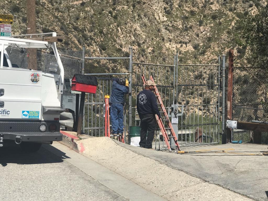
The county erected a new locked gate at Pinecrest well before the ANF closure order that took effect on 4/4. Interesting that gate morphed from Pasadena to county. I’m very bummed they rebuilt the pedestrian gate.
Interesting that the Forest Order does not close anything in San Gabriel Canyon, the most crowded place in the Angeles NF. I guess the people who frequent the area have herd immunity that people who recreate elsewhere do not. ?
I'm not sure how they intend to enforce this order since the Supervisor's office in Arcadia has spent almost their entire budget hiring office support and "ologists" who work in the Arcadia office. There are frequently days with nobody assigned to work on the ground in the forest, and the days there are it's often just one or two to empty garbage bins and clean restrooms.
I'm not sure how they intend to enforce this order since the Supervisor's office in Arcadia has spent almost their entire budget hiring office support and "ologists" who work in the Arcadia office. There are frequently days with nobody assigned to work on the ground in the forest, and the days there are it's often just one or two to empty garbage bins and clean restrooms.
I, for one, am very happy to have clean restrooms at trailheads, and garbage cans that aren't overflowing. Trailheads are where the most people are, so it makes sense that limited government services are concentrated there. A lot of people never hike more than half a mile from the trailhead before turning around. A lot of them never leave the trailhead area. They sit down and have a picnic with their family right there, or they take their kids sledding next to the parking lot.
What does bug me a little is when I stop in at a ranger station to ask about conditions, and they not only don't know (because they don't get out on the trails), but they won't admit they don't know.
I'd be willing to bet money that the people you talk to in the station haven't been on a trail in the Angeles in more than a decade. Most of them have not even driven into the forest, and those that do often will not get out of their vehicles while there. I always got the vibe that most of the staff looked down their noses at the ones who work in the field, like the way you might imagine a high-power attorney looking down on a janitor.
I'm not trying to badmouth the Forest Service. I've been to countless forests in dozens of states that are filled with dedicated people who have a real drive to be a service to the public and manage the land they're charged with. There's something peculiar about the way the Angeles works, though, that sets it apart from every other forest I've ever experienced. It's persisted through many different Supervisors, staff changes, and Regional Foresters, so I've never been able to put my finger on the cause. But it's something you don't even find on the San Bernardino or Los Padres right next door. One day I'll figure it out.