The Agua Blanca Trail can be described as one of the most scenic in the Ojai Ranger District in the Los Padres National Forest. That's the good news.
To get to the trailhead - it is easier said than done. It is remote - you should not expect to see anyone on your adventure. The trail follows the Agua Blanca Creek - both in the creek bed and perhaps as high as 100 feet above it. It can be difficult to follow the trail while in the creek bed - the trail is obliterated following heavy rains. The rock hopping, sandy floor, and lack of a trail tread in the creek bed makes it physically strenuous. It is dangerous in the winter months due to high water and the numerous water crossings. It is further complicated and challenging trying to avoid the large amount of poison oak found there - although we didn't see much until past the Gateway. That's the bad news.
So why would you want to go there?
I saw the name "Devil's Gateway" on a topo map of the Los Padres backcountry. I was immediately intrigued. And after I only found a handful of outdated trip reports and only one photo of it on the internet (which really didn't do it justice) - I became even more intrigued. How could I not want to go there?
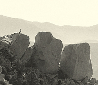
The "Devil's Gateway" is a 20 foot wide slot, rising more than 100 feet above the creek bed, and is only about 200 feet long. During low water it can be rock-hopped / waded. Medium water might mean waist high. High water - impassible. There is / was a trail up and around the Gateway but it is washed out in places.
Alan Coles, a true friend of the Los Padres, has been coming to Agua Blanca for many years. He has taken the Agua Blanca / Pothole Trails under his wing. He leads several trips each year attempting to maintain the trails.
A large portion of the Agua Blanca trail was lost in the floods of 2005. His efforts to preserve the trail are constantly being challenged by post-storm water flows that continually remove most of the trail on the creek bed floor and have collapsed benches alongside the creek.
As part of a National Forest Service sponsored trail maintenance event, we met Alan at the Temescal Fire Station of the National Forest Service, just outside the gates of the Lake Piru Recreational Area. By going with this group the Recreational Area entry fee is avoided. More importantly, it allows a ride through three normally-locked gates to get close to the trailhead, thereby avoiding about a 7 mile (one way) road hike.
After parking - previously arranged by Alan - at the old Whitaker homesite - think Little House on the Prairie, a private homestead within the Forest - we loaded up and began hiking at 09:45.

We hiked on a well-maintained dirt road through a turnstile (!) at the fourth locked gate onto another private holding within the Forest. Within minutes we crossed the first of our many stream crossings. We wondered at the modest private residence we passed by. Their BBQ pit could literally hold a small herd of cattle. And then began the trail.

We rock-hopped across the stream bed maybe 12 times. We plodded in the dry bed. We roller-coastered on the sections of the trail that do remain undamaged on the hillside. We entered the Sespe Wilderness. All the while searching for and following the yellow plastic streamers tied to the vegetation branches that have been left by previous explorers. Due to our group being on the north side of the mountain range the trip was cool. Summer could be blazing.

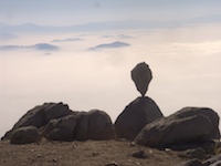
At 11:45 we reached the Gateway at about 3 miles. Wow. It is impressive. One can only imagine what it would be like if flooded! But today it was tranquil with the clear, cool water flowing gently over the sandy bottom. The quiet was broken only by the gentle gurgling of the creek. Totally in the shade.
The water level, although 6 inches to maybe a foot deep, required either water shoes, bare feet, or in my case just rock hopping and hoping for shallow water when my waterproof mid-high boots found the bottom while venturing through the Gateway.

We crossed the creek again, avoiding the apparently dormant poison oak forest, and continued up the Pothole Trail towards the Pothole. That trail would make a nice loop when the days are longer. After eating a quick trailside lunch, we began clearing the overgrown path of the fallen trees, vines and brush which was today's objective.
As I was riding with the Ojai Ranger District Trail Manager Heidi Anderson, and her schedule required her to be back at the Ojai Range Station in Ojai by 18:00, we left the rest of the crew still working at 13:39.


From just above the Gateway, the hike back to the truck took about two hours.
Surprisingly, all day, we saw no wildlife other than a few birds. It may be that we made too much noise.
After that work, the loop of The Pothole Trail / Agua Blanca Trail is now complete.
Directions: I-5 North to Highway 126, turning north on Main Street in Piru - which becomes Piru Canyon Road. Travel about 7 miles. To avoid the fees and a long, not-very-interesting road hike, advise parking outside the recreational area - watch for the No Parking signs - and bike riding past the entrance, the locked gate at about one mile, the second boat launch ramp at 2.3 miles from the gate, and leaving the bike hidden at the Blue Point Campground (not in use due to the endangered Arroyo toad) at 4.2 miles from the 2nd launch ramp - and beginning your hike there. No vehicular traffic is allowed to the campground so your belongings should be safe, if hidden. From Blue Point it's about another 1 1/2 miles across the creek twice and through two private properties to the unmarked - but readily found - trailhead.
Cobblestone Mountain topo. Google Earth would help too.
Don't advise solo travel. Too remote and fraught with dangers. The canyon has high sides - cell reception was not attempted - satellite might work, or not.
More pics here: http://picasaweb.google.com/bardley.smith/AguaBlanca#